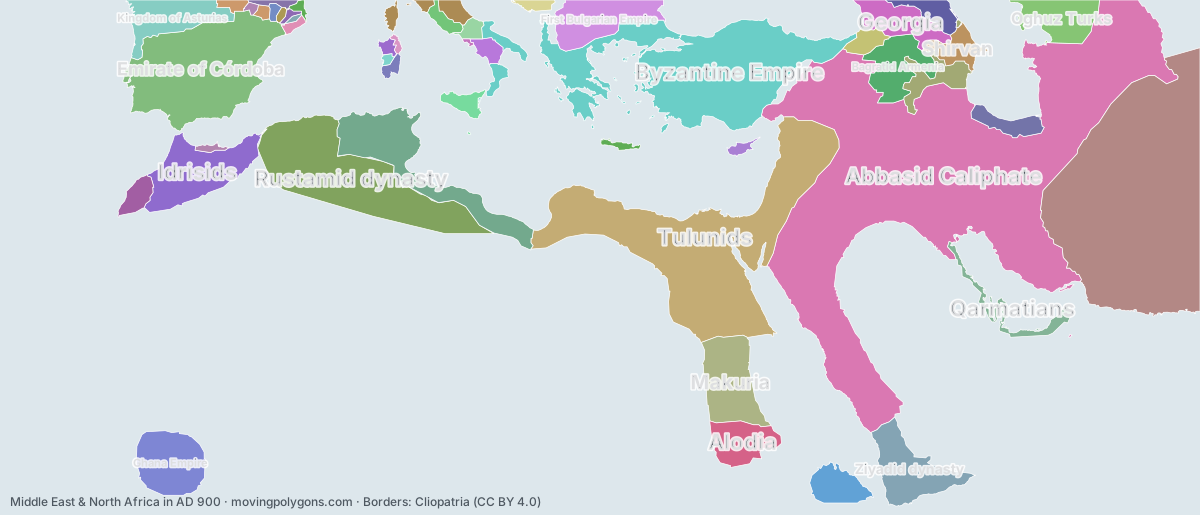
Middle East & North Africa in AD 900
This map shows the 48 states and peoples the data has for Middle East & North Africa in that year.
Watch these borders move
Play the changes on an animated map, in your browser. Free, no account needed.
States and peoples in Middle East & North Africa in AD 900
Largest first, by area on this map.
- Abbasid Caliphate
- Samanid Empire
- Tulunids
- Byzantine Empire
- Rustamid dynasty
- Emirate of Córdoba
- Aghlabid Dynasty
- Idrisids
- Makuria
- Ziyadid dynasty
- Ghana Empire
- First Bulgarian Empire
- Kingdom of Asturias
- Alodia
- Bagratid Armenia
- Oghuz Turks
- Georgia
- Kingdom of Axum
- Sajid Dynasty
- Qarmatians
- Shirvan
- Zaydi Alid dynasties
- Khazaria
- Kingdom of Lower Burgundy
- Barghawata Conference
- Kingdom of the Iberians
- Emirate of Sicily
- Principality of Salerno
- Papal States
- County of Ribagorza
- Duchy of Benevento
- Principality of Serbia
- Giudicato of Cagliari
- Cyprus Condominium
- West Franks
- Emirate of Crete
- Giudicato of Logudoro
- County of Barcelona
- Emirate of Nekor
- County of Rosellón
- County of Pallars
- County of Berga
- Giudicato of Gallura
- County of Aragon
- Giudicato of Arborea
- County of Urgell
- County of Besalú
- Duchy of Naples
New on the map since AD 800
Samanid Empire · Tulunids · Ziyadid dynasty · Bagratid Armenia · Sajid Dynasty · Qarmatians · Shirvan · Zaydi Alid dynasties · Kingdom of Lower Burgundy · Kingdom of the Iberians · Emirate of Sicily · Principality of Salerno · County of Ribagorza · Giudicato of Cagliari · West Franks · Emirate of Crete · Giudicato of Logudoro · County of Barcelona · County of Rosellón · County of Pallars · County of Berga · Giudicato of Gallura · County of Aragon · Giudicato of Arborea · County of Urgell · County of Besalú
Gone from the map by 1000
Abbasid Caliphate · Samanid Empire · Tulunids · Rustamid dynasty · Emirate of Córdoba · Aghlabid Dynasty · Idrisids · Kingdom of Asturias · Kingdom of Axum · Sajid Dynasty · Zaydi Alid dynasties · Khazaria · Kingdom of Lower Burgundy · Kingdom of the Iberians · Principality of Serbia · Cyprus Condominium · West Franks · Emirate of Crete · County of Aragon · County of Besalú
Animated maps of this time
Middle East & North Africa in other years
Other regions in AD 900
The outlines are coarse and follow the Cliopatria dataset: borders before modern surveys are estimates, and a blank area means the data has no state on record there, not that nobody lived there. A state that changed hands during the year can appear together with its successor.