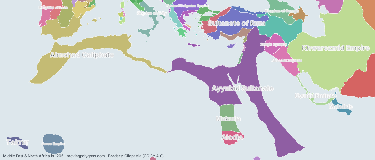
Middle East & North Africa in 1206
1206 is the year Genghis Khan united the Mongols. This map shows the 56 states and peoples the data has for Middle East & North Africa in that year.
Watch these borders move
Play the changes on an animated map, in your browser. Free, no account needed.
States and peoples in Middle East & North Africa in 1206
Largest first, by area on this map.
- Khwarezmid Empire
- Ayyubid Sultanate
- Almohad Caliphate
- Ghurid Dynasty
- Sultanate of Rum
- Hamdanid Emirates
- Makuria
- Sosso Empire
- Abbasid Caliphate
- Kingdom of Georgia
- Second Bulgarian Empire
- Kara-Khitans
- Kingdom of Castile
- Zengid dynasty
- Kingdom of Sicily
- Alodia
- Nicaean Empire
- Kimek-Kipchak confederation
- Kingdom of León
- Crown of Aragon
- Mahdids
- Latin Empire
- Armenian Kingdom of Cilicia
- Takrur
- Kingdom of Portugal
- Uyunid Emirate
- Despotate of Epirus
- Shirvan
- Kingdom of Thessalonica
- Empire of Trebizond
- Principality of Achaea
- Republic of Pisa
- Papal States
- Kingdom of Serbia
- Republic of Venice
- Holy Roman Empire
- Zagwe dynasty
- County of Berga
- Kingdom of Jerusalem
- Kingdom of Cyprus
- Duchy of Athens
- Empire of Kanem
- Giudicato of Logudoro
- Kingdom of Navarre
- Principality of Antioch
- County of Urgell
- County of Toulouse
- Giudicato of Gallura
- Angevin Empire
- Giudicato of Arborea
- County of Tripoli
- Negroponte
- Byzantine Empire
- Domain of Rhodes
- County of Ampuria
- Republic of Genoa
New on the map since 1156
Khwarezmid Empire · Ayyubid Sultanate · Sosso Empire · Abbasid Caliphate · Second Bulgarian Empire · Nicaean Empire · Kingdom of León · Crown of Aragon · Mahdids · Latin Empire · Despotate of Epirus · Kingdom of Thessalonica · Empire of Trebizond · Principality of Achaea · Kingdom of Serbia · Republic of Venice · County of Berga · Kingdom of Cyprus · Duchy of Athens · Negroponte · Domain of Rhodes · Republic of Genoa
Gone from the map by 1256
Khwarezmid Empire · Ayyubid Sultanate · Ghurid Dynasty · Sosso Empire · Kingdom of Georgia · Kara-Khitans · Kingdom of Castile · Kimek-Kipchak confederation · Kingdom of León · Takrur · Uyunid Emirate · Shirvan · Kingdom of Thessalonica · County of Berga · County of Urgell · County of Toulouse · Giudicato of Gallura · Angevin Empire · Negroponte · Byzantine Empire · Domain of Rhodes
Animated maps of this time
Middle East & North Africa in other years
Other regions in 1206
The outlines are coarse and follow the Cliopatria dataset: borders before modern surveys are estimates, and a blank area means the data has no state on record there, not that nobody lived there. A state that changed hands during the year can appear together with its successor.