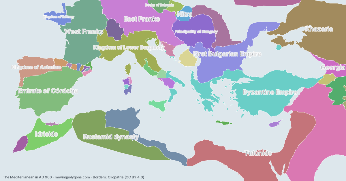
The Mediterranean in AD 900
This map shows the 49 states and peoples the data has for The Mediterranean in that year.
Watch these borders move
Play the changes on an animated map, in your browser. Free, no account needed.
States and peoples in the Mediterranean in AD 900
Largest first, by area on this map.
- Abbasid Caliphate
- Tulunids
- Byzantine Empire
- Khazaria
- Rustamid dynasty
- Emirate of Córdoba
- West Franks
- East Franks
- First Bulgarian Empire
- Kingdom of Lower Burgundy
- Aghlabid Dynasty
- Principality of Hungary
- Idrisids
- Kingdom of Asturias
- Magyars
- Bagratid Armenia
- Georgia
- Kievan Rus'
- Kingdom of Brittany
- Upper Burgundy
- Principality of Serbia
- Duchy of Bohemia
- Barghawata Conference
- Nitra
- Kingdom of the Iberians
- Emirate of Sicily
- Great Moravia
- Duchy of Croatia
- County of Ribagorza
- Principality of Salerno
- Papal States
- Duchy of Benevento
- Giudicato of Cagliari
- Cyprus Condominium
- Emirate of Crete
- Giudicato of Logudoro
- County of Barcelona
- Sajid Dynasty
- Emirate of Nekor
- County of Rosellón
- County of Pallars
- County of Berga
- Republic of Venice
- Giudicato of Gallura
- County of Aragon
- Giudicato of Arborea
- County of Urgell
- County of Besalú
- Duchy of Naples
New on the map since AD 800
Tulunids · West Franks · East Franks · Kingdom of Lower Burgundy · Principality of Hungary · Magyars · Bagratid Armenia · Kievan Rus' · Kingdom of Brittany · Upper Burgundy · Duchy of Bohemia · Nitra · Kingdom of the Iberians · Emirate of Sicily · Great Moravia · County of Ribagorza · Principality of Salerno · Giudicato of Cagliari · Emirate of Crete · Giudicato of Logudoro · County of Barcelona · Sajid Dynasty · County of Rosellón · County of Pallars · County of Berga · Giudicato of Gallura · County of Aragon · Giudicato of Arborea · County of Urgell · County of Besalú
Gone from the map by 1000
Abbasid Caliphate · Tulunids · Khazaria · Rustamid dynasty · Emirate of Córdoba · West Franks · East Franks · Kingdom of Lower Burgundy · Aghlabid Dynasty · Principality of Hungary · Idrisids · Kingdom of Asturias · Magyars · Kingdom of Brittany · Upper Burgundy · Principality of Serbia · Nitra · Kingdom of the Iberians · Great Moravia · Duchy of Croatia · Cyprus Condominium · Emirate of Crete · Sajid Dynasty · County of Aragon · County of Besalú
Animated maps of this time
The Mediterranean in other years
Other regions in AD 900
The outlines are coarse and follow the Cliopatria dataset: borders before modern surveys are estimates, and a blank area means the data has no state on record there, not that nobody lived there. A state that changed hands during the year can appear together with its successor.