Europe in 1850
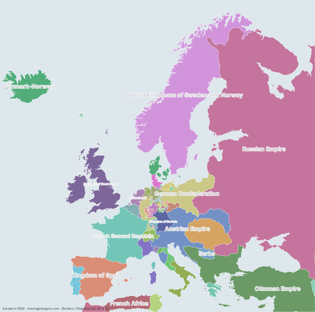
This map shows the 53 states and peoples the data has for Europe in that year.
Watch these borders move
Play the changes on an animated map, in your browser. Free, no account needed.
States and peoples in Europe in 1850
Largest first, by area on this map.
- Russian Empire
- Ottoman Empire
- United Kingdoms of Sweden and Norway
- French Second Republic
- Kingdom of Spain
- Austrian Empire
- Kingdom of Great Britain
- German Confederation
- Hungarian Nationalists
- Denmark-Norway
- French Africa
- Kingdom of the Two Sicilies
- Kingdom of Portugal
- Kingdom of Bavaria
- Kingdom of Sardinia
- Beylik of Tunis
- Morocco
- Kingdom of Hanover
- Netherlands
- Swiss Confederation
- First Hellenic Republic
- Serbs
- Papal States
- Kingdom of Belgium
- Duchy of Holstein
- Duchy of Warsaw
- Republic of Baden
- Kingdom of Württemberg
- Electorate of Hesse
- Qajar Dynasty
- Duchy of Mecklenburg
- Grand Duchy of Hesse
- Duchy of Parma and Piacenza
- Duchy of Modena and Reggio
- Duchy of Nassau
- Duchy of Brunswick
- Duchy of Oldenburg
- Grand Duchy of Saxe-Weimar-Eisenach
- Saxe-Meiningen
- Free City of Lübeck
- Duchy of Anhalt
- Principality of Reuss-Gera
- Saxe-Altenburg
- Principality of Hohenzollern-Sigmaringen
- Free City of Hamburg
- Principality of Schwarzburg-Sonderhausen
- Caucasian Imamate
- Principality of Waldeck and Pyrmont
- Principality of Lippe
- Free City of Bremen
- Principality of Andorra
- Free City of Frankfurt
- Kingdom of Monaco
New on the map since 1825
French Second Republic · Hungarian Nationalists · French Africa · Kingdom of Hanover · Kingdom of Belgium · Duchy of Holstein · Republic of Baden · Caucasian Imamate
Gone from the map by 1875
French Second Republic · Kingdom of Spain · Austrian Empire · German Confederation · Hungarian Nationalists · Kingdom of the Two Sicilies · Kingdom of Bavaria · Kingdom of Sardinia · Kingdom of Hanover · Papal States · Duchy of Holstein · Duchy of Warsaw · Republic of Baden · Kingdom of Württemberg · Electorate of Hesse · Duchy of Mecklenburg · Grand Duchy of Hesse · Duchy of Parma and Piacenza · Duchy of Modena and Reggio · Duchy of Nassau · Duchy of Brunswick · Duchy of Oldenburg · Grand Duchy of Saxe-Weimar-Eisenach · Saxe-Meiningen · Free City of Lübeck · Duchy of Anhalt · Principality of Reuss-Gera · Saxe-Altenburg · Principality of Hohenzollern-Sigmaringen · Free City of Hamburg · Principality of Schwarzburg-Sonderhausen · Caucasian Imamate · Principality of Waldeck and Pyrmont · Principality of Lippe · Free City of Bremen · Free City of Frankfurt
Animated maps of this time
Europe in other years
Other regions in 1850
The outlines are coarse and follow the Cliopatria dataset: borders before modern surveys are estimates, and a blank area means the data has no state on record there, not that nobody lived there. A state that changed hands during the year can appear together with its successor.