The world in 1914
1914 is the eve of the First World War. This map shows the 74 states and peoples the data has for the world in that year.
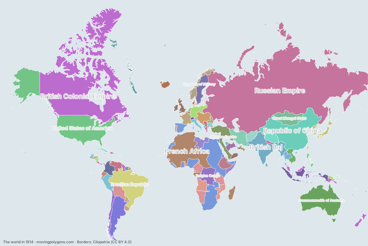
Watch these borders move
Play the changes on an animated map, in your browser. Free, no account needed.
States and peoples in the world in 1914
Largest first, by area on this map.
- Russian Empire
- British Colonial Empire
- United States of America
- French Africa
- Republic of China
- British Africa
- Brazilian Republic
- Commonwealth of Australia
- British Raj
- Argentine Confederation
- German Africa
- Belgian Congo
- Ottoman Empire
- Great Mongol State
- Portuguese Republic
- Qajar Dynasty
- Dutch East Indies
- Italian Africa
- Bolivia
- Republic of Peru
- Ethiopian Empire
- Republic of Colombia
- German Empire
- Tibet
- Kingdom of Spain
- Austria-Hungary
- Kingdom of Sweden
- Kingdom of Great Britain
- Venezuela
- Republic of Chile
- Empire of Japan
- French Third Republic
- French Indochina
- Emirate of Afghanistan
- Kingdom of Norway
- Rattanakosin Kingdom
- Emirate of Nejd
- Kingdom of Italy
- Greenland
- Denmark-Norway
- Republic of Ecuador
- Oriental Republic of Uruguay
- United Principalities of Moldavia and Wallachia
- Paraguay
- Nepal
- Principality of Bulgaria
- First Hellenic Republic
- Netherlands Antilles
- Republic of Nicaragua
- Serbs
- Honduras
- Republic of Cuba
- Guatemala
- Imamate of Oman
- Republic of Liberia
- Emirate of Jabal Shammar
- Republic of Panama
- Netherlands
- Swiss Confederation
- Republic of Costa Rica
- Dominican Republic
- Kingdom of Belgium
- Kingdom of Bhutan
- Albania
- Empire of Haiti
- Republic of El Salvador
- Montenegro
- Sultanate of Muscat and Oman
- Qatar
- New Hebrides
- Luxembourg
- Tangier International Zone
- Principality of Andorra
- Kingdom of Monaco
New on the map since 1889
Republic of China · Brazilian Republic · Commonwealth of Australia · Belgian Congo · Great Mongol State · Portuguese Republic · Italian Africa · Tibet · Kingdom of Sweden · Kingdom of Norway · Republic of Cuba · Imamate of Oman · Republic of Panama · Albania · Sultanate of Muscat and Oman · Qatar · New Hebrides · Luxembourg · Tangier International Zone
Gone from the map by 1939
Russian Empire · Brazilian Republic · Argentine Confederation · German Africa · Ottoman Empire · Great Mongol State · Portuguese Republic · Qajar Dynasty · Ethiopian Empire · German Empire · Kingdom of Spain · Austria-Hungary · Emirate of Afghanistan · Rattanakosin Kingdom · Emirate of Nejd · United Principalities of Moldavia and Wallachia · Serbs · Imamate of Oman · Emirate of Jabal Shammar · Albania · Empire of Haiti · Montenegro · Qatar
Animated maps of this time
The world in other years
Other regions in 1914
The outlines are coarse and follow the Cliopatria dataset: borders before modern surveys are estimates, and a blank area means the data has no state on record there, not that nobody lived there. A state that changed hands during the year can appear together with its successor.