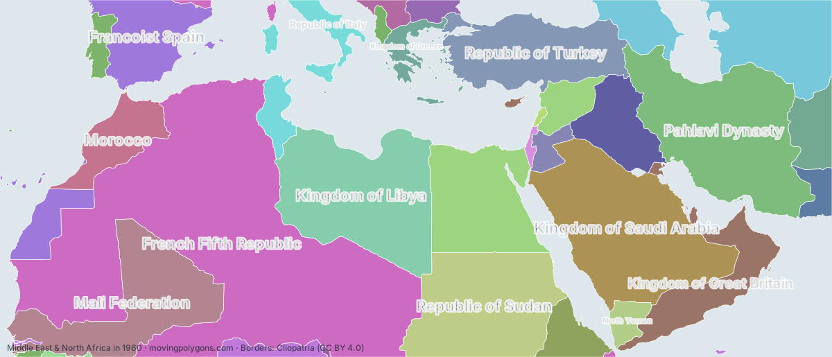
Middle East & North Africa in 1960
This map shows the 31 states and peoples the data has for Middle East & North Africa in that year.
Watch these borders move
Play the changes on an animated map, in your browser. Free, no account needed.
States and peoples in Middle East & North Africa in 1960
Largest first, by area on this map.
- French Fifth Republic
- Kingdom of Saudi Arabia
- Pahlavi Dynasty
- Kingdom of Libya
- Republic of Sudan
- Mali Federation
- United Arab Republic
- Union of Soviet Socialist Republics
- Republic of Turkey
- Francoist Spain
- Kingdom of Great Britain
- Iraqi Republic
- Morocco
- Kingdom of Afghanistan
- Ethiopia
- Republic of Italy
- British Africa
- Republic of Tunisia
- Kingdom of Greece
- North Yemen
- Islamic Republic of Pakistan
- Estado Novo
- Kingdom of Jordan
- People's Republic of Bulgaria
- Socialist Federal Republic of Yugoslavia
- People's Socialist Republic of Albania
- State of Israel
- Guinea
- Lebanon
- Republic of Cameroon
- Principality of Andorra
New on the map since 1935
French Fifth Republic · Kingdom of Saudi Arabia · Kingdom of Libya · Republic of Sudan · Mali Federation · United Arab Republic · Francoist Spain · Iraqi Republic · Morocco · Ethiopia · Republic of Italy · Republic of Tunisia · Kingdom of Greece · Islamic Republic of Pakistan · Kingdom of Jordan · People's Republic of Bulgaria · Socialist Federal Republic of Yugoslavia · People's Socialist Republic of Albania · State of Israel · Guinea · Lebanon · Republic of Cameroon
Gone from the map by 1985
Pahlavi Dynasty · Kingdom of Libya · United Arab Republic · Francoist Spain · Kingdom of Afghanistan · British Africa · Kingdom of Greece · Estado Novo
Animated maps of this time
Middle East & North Africa in other years
Other regions in 1960
The outlines are coarse and follow the Cliopatria dataset: borders before modern surveys are estimates, and a blank area means the data has no state on record there, not that nobody lived there. A state that changed hands during the year can appear together with its successor.