Europe in 1000
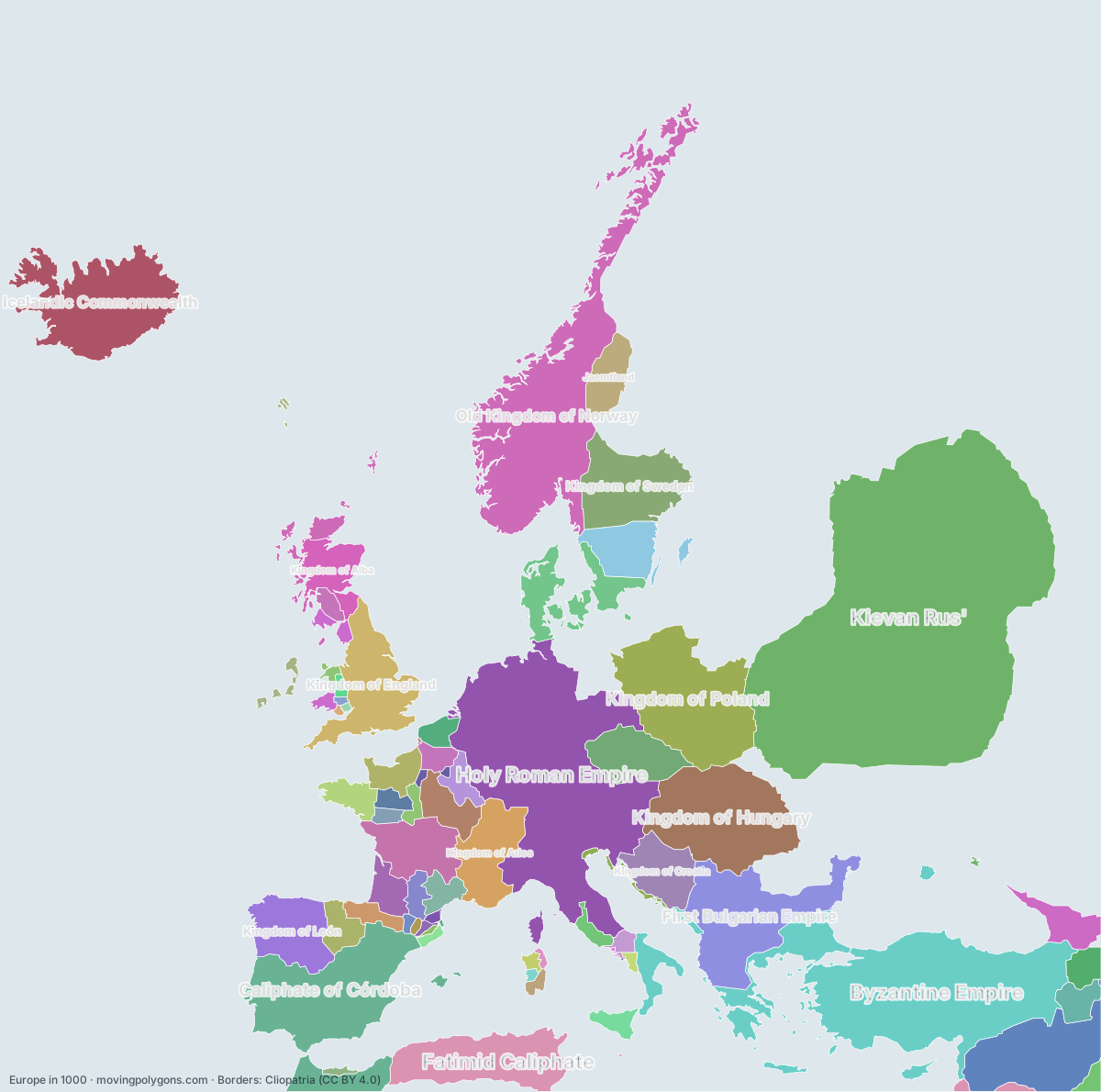
This map shows the 69 states and peoples the data has for Europe in that year.
Watch these borders move
Play the changes on an animated map, in your browser. Free, no account needed.
States and peoples in Europe in 1000
Largest first, by area on this map.
- Kievan Rus'
- Byzantine Empire
- Holy Roman Empire
- Caliphate of Córdoba
- Old Kingdom of Norway
- Kingdom of Hungary
- Kingdom of Poland
- First Bulgarian Empire
- Hamdanid Emirates
- Fatimid Caliphate
- Icelandic Commonwealth
- Kingdom of England
- Kingdom of Sweden
- Kingdom of León
- Kingdom of Arles
- Duchy of Aquitaine
- Kingdom of Croatia
- Duchy of Bohemia
- Kingdom of Denmark
- Scandinavian minor kingdoms
- Kingdom of Alba
- Georgia
- Kingdom of France
- Jaemtland
- Duchy of Gascony
- Kingdom of Castile
- Duchy of Normandy
- Kingdom of Vaspurakan
- Duchy of Brittany
- Bagratid Armenia
- County of Rouergue
- County of Champagne
- County of Ribagorza
- Emirate of Sicily
- County of Toulouse
- County of Flanders
- County of Vermandois
- Brythons
- Papal States
- County of Maine
- Buyid Dynasty
- Duchy of Benevento
- County of Blôis
- Strathclyde
- County of Anjou
- Viking settlements
- Giudicato of Cagliari
- Republic of Venice
- Giudicato of Logudoro
- County of Barcelona
- Emirate of Nekor
- Kingdom of Gwynedd
- Principality of Salerno
- Kingdom of Powys
- County of Vexin
- County of Pallars
- County of Berga
- County of Rosellón
- Giudicato of Gallura
- Giudicato of Arborea
- County of Urgell
- Kingdom of Brycheiniog
- County of Osona
- Kingdom of Morgannwg
- Kingdom of Gwent
- Duchy of Naples
- County of Ampuria
- Principality of Capua
- Republic of Amalfi
New on the map since AD 950
Holy Roman Empire · Kingdom of Hungary · Kingdom of Poland · Kingdom of Sweden · Duchy of Aquitaine · Kingdom of France · Duchy of Gascony · Kingdom of Castile · County of Rouergue · County of Champagne · Emirate of Sicily · County of Toulouse · County of Flanders · County of Vermandois · County of Maine · Buyid Dynasty · County of Blôis · County of Anjou · Kingdom of Gwynedd · Kingdom of Powys · County of Vexin · County of Osona · Kingdom of Gwent · County of Ampuria · Principality of Capua · Republic of Amalfi
Gone from the map by 1050
Old Kingdom of Norway · First Bulgarian Empire · Kingdom of León · Duchy of Bohemia · Kingdom of Denmark · Scandinavian minor kingdoms · Georgia · Kingdom of Vaspurakan · Bagratid Armenia · Duchy of Benevento · Strathclyde · Emirate of Nekor · Kingdom of Powys · County of Pallars · Principality of Capua · Republic of Amalfi
Animated maps of this time
Europe in other years
Other regions in 1000
The outlines are coarse and follow the Cliopatria dataset: borders before modern surveys are estimates, and a blank area means the data has no state on record there, not that nobody lived there. A state that changed hands during the year can appear together with its successor.