The world in 1530
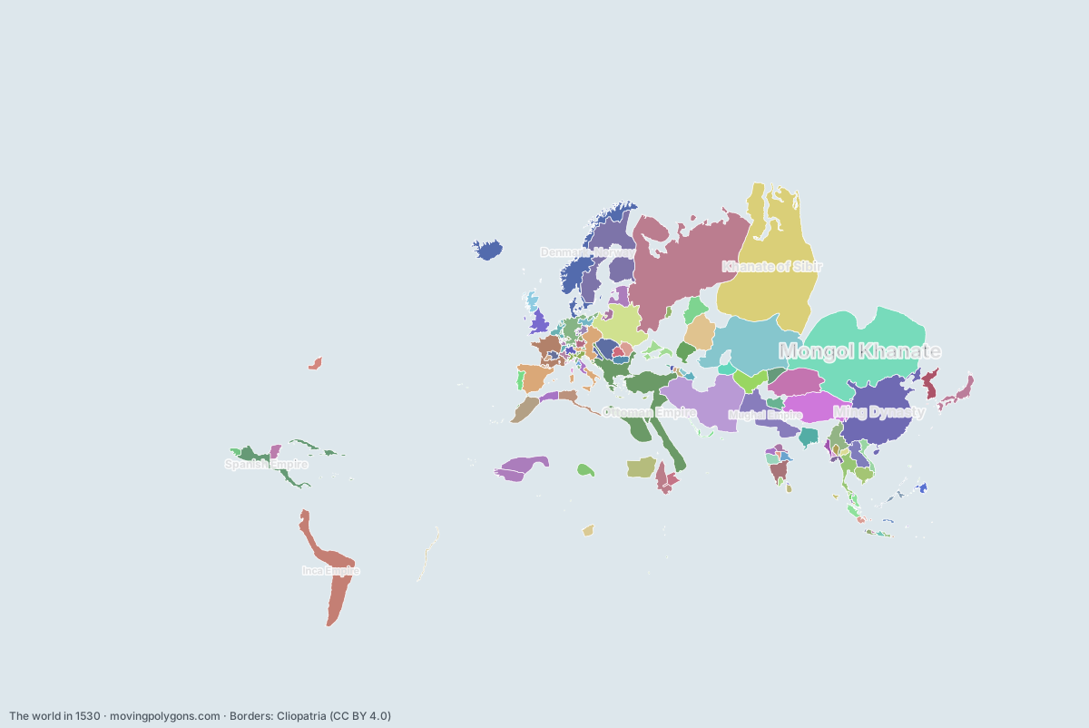
This map shows the 124 states and peoples the data has for the world in that year.
Watch these borders move
Play the changes on an animated map, in your browser. Free, no account needed.
States and peoples in the world in 1530
Largest first, by area on this map.
- Mongol Khanate
- Khanate of Sibir
- Grand Principality of Moscow
- Ming Dynasty
- Kazakh Khanate
- Ottoman Empire
- Safavid Dynasty
- Inca Empire
- Tibet
- Kingdom of Sweden
- Mughal Empire
- Denmark-Norway
- House of Jagiellon
- Eastern Moghulistan
- Kingdom of Spain
- Spanish Empire
- Nogai Horde
- Songhai Empire
- Funj Sultanate
- Kingdom of France
- Khanate of Bukhara
- Holy Roman Empire Minor States
- Wattasid dynasty
- Shan States
- Ayutthaya Kingdom
- Lan Xang
- Ethiopian Empire
- Sultanate of Bengal
- Vijayanagara Empire
- Warring States Japan
- Mali Empire
- Kingdom of Hungary
- Khanate of Kazan
- Khmer Empire
- Joseon
- Hafsid Dynasty
- Kingdom of England
- Astrakhan Khanate
- Crimean Khanate
- Bornu Empire
- Sultanate of Johor
- Livonian Conference
- Sultanate of Brunei
- Kingdom of Portugal
- Đại Việt
- Western Moghulistan
- Kashmiri Sultanate
- Later Mayan City-States
- Khanate of Khiva
- Adal Sultanate
- Bijapur Sultanate
- Zayyanid dynasty
- Kingdom of Scotland
- Habsburg Monarchy
- Kingdom of Kongo
- Principality of Moldavia
- Portuguese Empire
- Golconda Sultanate
- Principality of Wallachia
- Haudenosaunee
- Sultanate of Maguindanao
- Kingdom of Mrauk U
- Republic of Venice
- Berar Sultanate
- Eastern Hungarian Kingdom
- Ahmadnagar Sultanate
- Michoacán
- Hanthawaddy Kingdom
- Sultanate of Palembang
- Electorate of Brandenburg
- Shirvan
- First Toungoo Empire
- Duchy of Prussia
- House of Bourbon
- Papal States
- Swiss Confederation
- Electorate of Saxony
- Lan Na Kingdom
- Duchy of Bavaria
- County of Savoy
- Nayaks of Madurai
- Portuguese Ceylon
- Demak Sultanate
- Qasim Khanate
- County of Foix
- Sunda Kingdom
- Kingdom of Georgia
- Sultanate of Banjar
- Bidar Sultanate
- Kingdom of Kakheti
- Portuguese Africa
- Blambangan Kingdom
- Duchy of Lorraine
- Electorate of Trier
- Sultanate of Aceh
- Duchy of Milan
- Sultanate of Perak
- Prome Kingdom
- Republic of Genoa
- Principality of Mingrelia
- Sultanate of Malacca
- Republic of Florence
- Kingdom of Imereti
- Sultanate of Kedah
- Jaffna kingdom
- Principality of Abkhazia
- Sultanate of Cirebon
- Sultanate of Banten
- Chámpa
- Principality of Guria
- Balinese Kingdom
- Rajahnate of Cebu
- Tondo
- Comtat Venaissin
- Sultanate of Bone
- Republic of Ragusa
- Sultanate of Sulu
- Maynila
- Sultanate of Gowa
- Ashikaga Shogunate
- Namayan
- Kathmandu
- County of Urgell
- Principality of Orange
New on the map since 1505
Mughal Empire · Denmark-Norway · Eastern Moghulistan · Kingdom of Spain · Spanish Empire · Funj Sultanate · Khanate of Bukhara · Sultanate of Johor · Đại Việt · Western Moghulistan · Khanate of Khiva · Golconda Sultanate · Sultanate of Maguindanao · Eastern Hungarian Kingdom · Duchy of Prussia · Nayaks of Madurai · Portuguese Ceylon · Sultanate of Banjar · Portuguese Africa · Blambangan Kingdom · Sultanate of Aceh · Duchy of Milan · Sultanate of Perak · Sultanate of Banten · Balinese Kingdom · Sultanate of Bone · Maynila · Sultanate of Gowa
Gone from the map by 1555
Grand Principality of Moscow · Sultanate of Bengal · Kingdom of Hungary · Khanate of Kazan · Later Mayan City-States · Adal Sultanate · Michoacán · Hanthawaddy Kingdom · Shirvan · County of Savoy · Demak Sultanate · Qasim Khanate · Duchy of Milan · Prome Kingdom
Animated maps of this time
The world in other years
Other regions in 1530
The outlines are coarse and follow the Cliopatria dataset: borders before modern surveys are estimates, and a blank area means the data has no state on record there, not that nobody lived there. A state that changed hands during the year can appear together with its successor.