The world in 1730
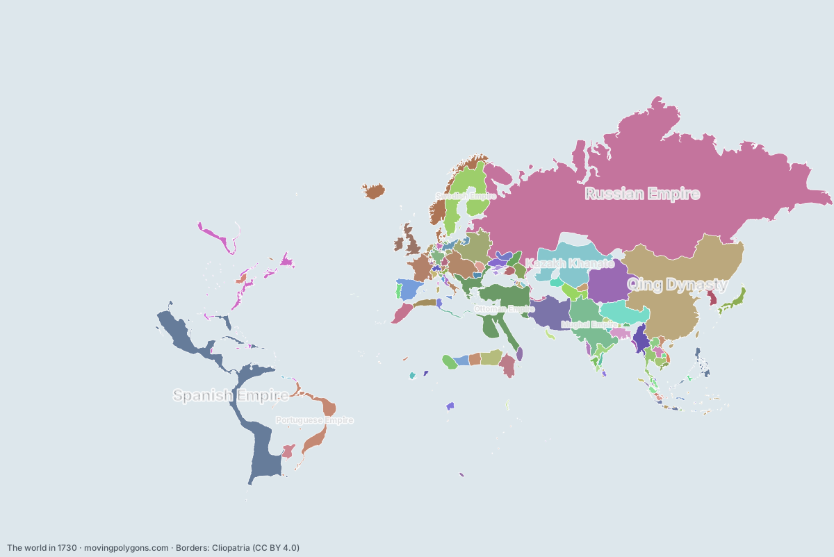
This map shows the 127 states and peoples the data has for the world in that year.
Watch these borders move
Play the changes on an animated map, in your browser. Free, no account needed.
States and peoples in the world in 1730
Largest first, by area on this map.
- Russian Empire
- Qing Dynasty
- Spanish Empire
- Ottoman Empire
- Kazakh Khanate
- Mughal Empire
- Dzungar Khanate
- Hotaki Dynasty
- Swedish Empire
- Portuguese Empire
- Tibet
- Polish-Lithuanian Commonwealth
- Habsburg Monarchy
- Denmark-Norway
- British Colonial Empire
- Kingdom of France
- Kingdom of Spain
- First Toungoo Empire
- Funj Sultanate
- Ethiopian Empire
- Kingdom of Great Britain
- Morocco
- Khanate of Bukhara
- Nawabs of Bengal
- Ayutthaya Kingdom
- Tokugawa Shogunate
- Bornu Empire
- Holy Roman Empire Minor States
- Sultanate of Darfur
- Wadai Empire
- Joseon
- Hyderabad State
- Jesuit Reducciones
- Regency of Algiers
- Dutch Republic
- Kalmyk Khanate
- New France
- Kingdom of Prussia
- Astrakhan Khanate
- Khmer Empire
- Vientiane
- Zaporozhian Cossacks
- Kingdom of Luang Phrabang
- Qasimids
- Khanate of Khiva
- Gorkha Kingdom
- Sultanate of Johor
- Sloboda Ukraine
- Yarubid dynasty
- Small Horde
- Principality of Moldavia
- Kingdom of Portugal
- Trịnh lords
- Maratha Empire
- Nawab of Awadh
- Khanate of Kokand
- Kingdom of Lunda
- Karamanli Dynasty
- Haudenosaunee
- Beylik of Tunis
- Kingdom of Sardinia
- Kingdom of Mysore
- Nguyễn lords
- Crimean Khanate
- Carnatic Sultanate
- Cambodia
- Ashanti Empire
- Sultanate of Palembang
- Principality of Wallachia
- Duchy of Bavaria
- Republic of Venice
- Swiss Confederation
- Kingdom of Mrauk U
- Papal States
- Sultanate of Brunei
- Sultanate of Malacca
- Sultanate of Banten
- Mataram Sultanate
- Nayaks of Madurai
- Electorate of Hanover
- Kingdom of Bhutan
- Oyo Empire
- Kingdom of Champasak
- Dutch Ceylon
- Sultanate of Sulu
- Kingdom of Georgia
- New Netherland
- Sultanate of Aceh
- Sultanate of Banjar
- Dutch Cape Coast
- Kingdom of Kakheti
- Sultanate of Jambi
- Republic of Florence
- Duchy of Lorraine
- Bamana Empire
- Portuguese Colonies
- Sultanate of Perak
- Republic of Genoa
- Kingdom of Imereti
- Blambangan Kingdom
- Sultanate of Terengganu
- Thanjavur Maratha Kingdom
- Principality of Abkhazia
- Sultanate of Kedah
- Sultanate of Bima
- Sultanate of Sukadana
- Kutai Kingdom
- French India
- Principality of Mingrelia
- Bali
- Principality of Guria
- Sultanate of Sambas
- Principality of Svaneti
- Đại Việt
- Comtat Venaissin
- Republic of Ragusa
- Sultanate of Bone
- Sultanate of Mempawah
- English Colonial Empire
- Danish India
- Saadi Sultanate
- Kathmandu
- Principality of Monaco
- County of Urgell
- Sultanate of Maguindanao
- Principality of Liechtenstein
- Safavid Dynasty
New on the map since 1705
Russian Empire · Hotaki Dynasty · British Colonial Empire · Kingdom of Great Britain · Nawabs of Bengal · Hyderabad State · Regency of Algiers · Vientiane · Kingdom of Luang Phrabang · Maratha Empire · Nawab of Awadh · Khanate of Kokand · Kingdom of Lunda · Karamanli Dynasty · Beylik of Tunis · Kingdom of Sardinia · Carnatic Sultanate · Electorate of Hanover · Kingdom of Champasak · Kingdom of Georgia · Kingdom of Kakheti · Duchy of Lorraine · Bamana Empire · Sultanate of Terengganu · Principality of Svaneti · Principality of Liechtenstein
Gone from the map by 1755
Hotaki Dynasty · Yarubid dynasty · Small Horde · Mataram Sultanate · Nayaks of Madurai · Republic of Florence · Blambangan Kingdom · Kutai Kingdom · Saadi Sultanate · Safavid Dynasty
Animated maps of this time
- Brazil — From Colony to Republic (1500–1909)
- The Ottoman Empire (1299–1923)
- The Making of the United States, 1492–2025: Native Nations and Colonial Powers
- Swedish Empire – Dynasties & Territories
- Lights Against the Sea: North Sea Shipwrecks and Lighthouses (1593–2026)
- Friesland Through the Ages (12 BC – 2019)
The world in other years
Other regions in 1730
The outlines are coarse and follow the Cliopatria dataset: borders before modern surveys are estimates, and a blank area means the data has no state on record there, not that nobody lived there. A state that changed hands during the year can appear together with its successor.