The world in 1630
This map shows the 109 states and peoples the data has for the world in that year.
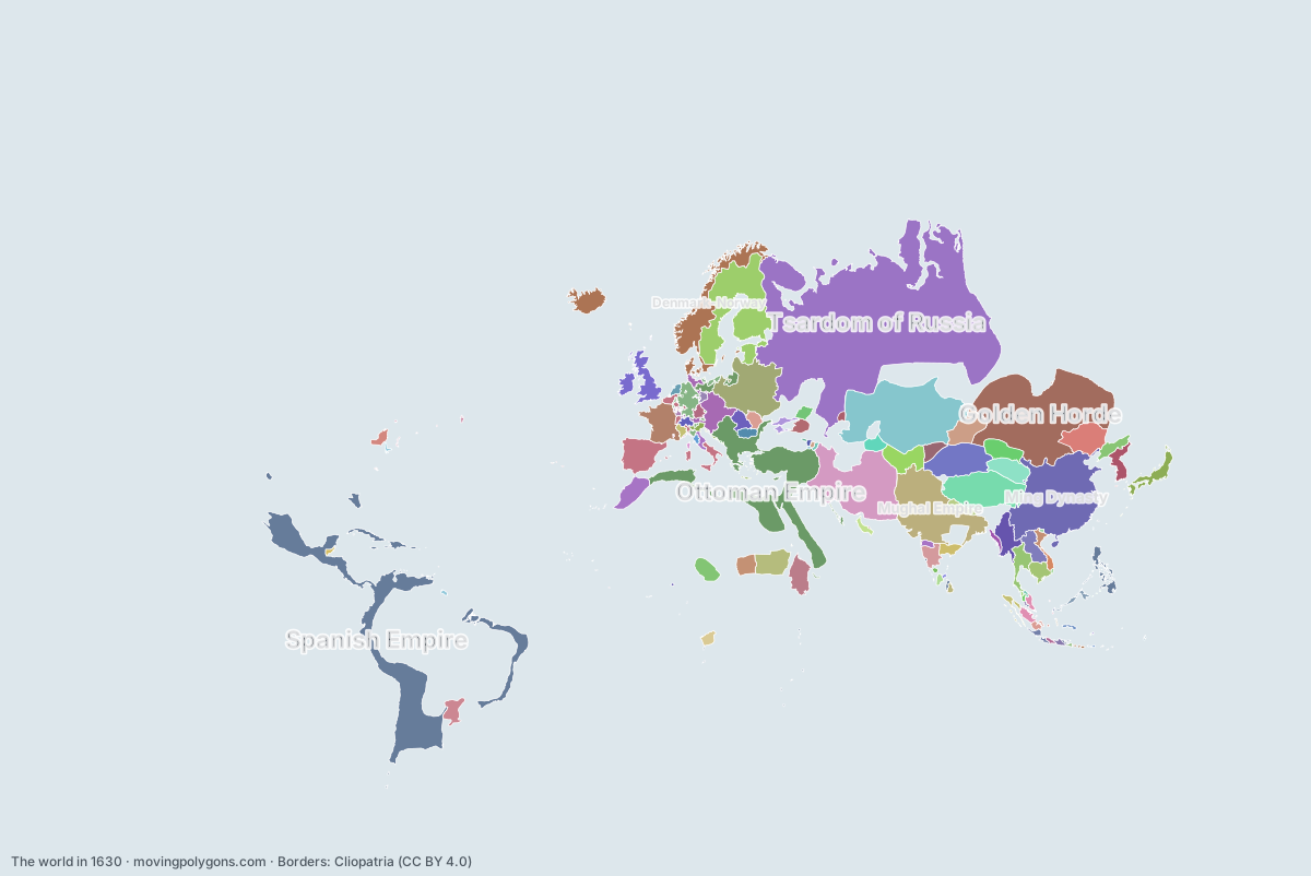
Watch these borders move
Play the changes on an animated map, in your browser. Free, no account needed.
States and peoples in the world in 1630
Largest first, by area on this map.
- Tsardom of Russia
- Spanish Empire
- Golden Horde
- Ming Dynasty
- Ottoman Empire
- Kazakh Khanate
- Safavid Dynasty
- Mughal Empire
- Tibet
- Swedish Empire
- Polish-Lithuanian Commonwealth
- Denmark-Norway
- Eastern Moghulistan
- Iberian Union
- Mongol Khanate
- Kingdom of France
- Funj Sultanate
- Habsburg Monarchy
- First Toungoo Empire
- Khanate of Bukhara
- Ethiopian Empire
- Kingdom of England
- Oirat Confederation
- Tümed
- Saadi Sultanate
- Holy Roman Empire Minor States
- Lan Xang
- Khoshut Khanate
- Ayutthaya Kingdom
- Tokugawa Shogunate
- Bornu Empire
- Sultanate of Darfur
- Bijapur Sultanate
- Jesuit Reducciones
- Joseon
- Khmer Empire
- Later Jin Dynasty
- Sultanate of Johor
- Western Moghulistan
- Golconda Sultanate
- Gorkha Kingdom
- Khanate of Khiva
- Principality of Transylvania
- Small Horde
- Brandenburg-Prussia
- Kingdom of Kongo
- Principality of Moldavia
- Trịnh lords
- Principality of Wallachia
- Sultanate of Aceh
- Haudenosaunee
- Sultanate of Brunei
- Don Cossacks
- Crimean Khanate
- Yarubid dynasty
- Nguyễn lords
- Kingdom of Mrauk U
- Sultanate of Banten
- Republic of Venice
- Sultanate of Palembang
- Duchy of Bavaria
- Swiss Confederation
- Dutch Republic
- Mataram Sultanate
- Sultanate of Malacca
- Papal States
- Ahmadnagar Sultanate
- House of Savoy
- Nayaks of Madurai
- Electorate of Saxony
- New Netherland
- Portuguese Ceylon
- Sultanate of Banjar
- Itza Mayans
- Sultanate of Cirebon
- Republic of Florence
- Duchy of Lorraine
- English Colonial Empire
- Sultanate of Perak
- Kingdom of Kartli
- Patani Kingdom
- Republic of Genoa
- Kingdom of Mysore
- Principality of Mingrelia
- Balinese Kingdom
- Kingdom of Imereti
- Blambangan Kingdom
- Nayaks of Thanjavur
- Sultanate of Kedah
- Đại Việt
- Principality of Abkhazia
- Sultanate of Bima
- Sultanate of Sukadana
- Chámpa
- Principality of Guria
- Oyo Empire
- Sultanate of Sambas
- Comtat Venaissin
- Sultanate of Bone
- Republic of Ragusa
- Sultanate of Sulu
- Sultanate of Mempawah
- Sultanate of Gowa
- Portuguese Colonies
- Kathmandu
- Huguenots
- County of Urgell
- Sultanate of Maguindanao
- New France
New on the map since 1605
Swedish Empire · Oirat Confederation · Sultanate of Darfur · Later Jin Dynasty · Brandenburg-Prussia · Yarubid dynasty · New Netherland · English Colonial Empire · Kingdom of Kartli · Principality of Mingrelia · Kingdom of Imereti · Principality of Abkhazia · Sultanate of Bima · Sultanate of Sukadana · Principality of Guria · Oyo Empire · Sultanate of Sambas · Sultanate of Mempawah · Huguenots · New France
Gone from the map by 1655
Ming Dynasty · Iberian Union · Mongol Khanate · Kingdom of England · Later Jin Dynasty · Western Moghulistan · Don Cossacks · Ahmadnagar Sultanate · Chámpa · Huguenots
Animated maps of this time
- Brazil — From Colony to Republic (1500–1909)
- The Ottoman Empire (1299–1923)
- The Making of the United States, 1492–2025: Native Nations and Colonial Powers
- Swedish Empire – Dynasties & Territories
- Lights Against the Sea: North Sea Shipwrecks and Lighthouses (1593–2026)
- Friesland Through the Ages (12 BC – 2019)
The world in other years
Other regions in 1630
The outlines are coarse and follow the Cliopatria dataset: borders before modern surveys are estimates, and a blank area means the data has no state on record there, not that nobody lived there. A state that changed hands during the year can appear together with its successor.