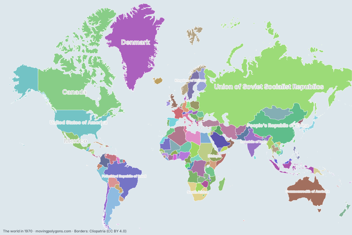
The world in 1970
This map shows the 141 states and peoples the data has for the world in that year.
Watch these borders move
Play the changes on an animated map, in your browser. Free, no account needed.
States and peoples in the world in 1970
Largest first, by area on this map.
- Union of Soviet Socialist Republics
- Canada
- United States of America
- People's Republic of China
- Federated Republic of Brazil
- Commonwealth of Australia
- Denmark
- French Fifth Republic
- Argentine Republic
- Republic of India
- People's Democratic Republic of Algeria
- Republic of Sudan
- Democratic Republic of the Congo
- South Africa
- Mongolian People's Republic
- Estado Novo
- Mexico
- Kingdom of Saudi Arabia
- Pahlavi Dynasty
- Republic of Indonesia
- Libyan Arab Republic
- Republic of Chad
- Mali Federation
- Republic of Peru
- Ethiopia
- Republic of the Niger
- Islamic Republic of Pakistan
- Republic of Colombia
- Bolivia
- Mauritania
- United Arab Republic
- Kingdom of Norway
- Republic of Turkey
- Francoist Spain
- Kingdom of Sweden
- Venezuela
- Federal Republic of Nigeria
- Tanzania
- Republic of Chile
- Kingdom of Great Britain
- Kingdom of Afghanistan
- Zambia
- Republic of Finland
- Burma
- Federal Republic of Somalia
- Madagascar
- Central African Republic
- Republic of Botswana
- Republic of Kenya
- Kingdom of Thailand
- Iraqi Republic
- Republic of Poland
- Morocco
- Republic of Cameroon
- Japan
- Papua New Guinea
- Paraguay
- Rhodesia
- Republic of Italy
- Federal Republic of Germany
- New Zealand
- Socialist Federal Republic of Yugoslavia
- Republic of the Congo
- Socialist Republic of Romania
- Malaysia
- Republic of Côte d'Ivoire
- People's Democratic Republic of Yemen
- Republic of the Philippines
- Burkina Faso
- Gabon
- Guinea
- Republic of Ecuador
- Ghana
- Republic of Iceland
- Kingdom of Laos
- Arab Socialist Ba'ath Party
- Guyana
- Republic of Uganda
- Oriental Republic of Uruguay
- Republic of Senegal
- Republic of Tunisia
- Kingdom of Cambodia
- German Democratic Republic
- Nepal
- Democratic Republic of Vietnam
- Greek junta
- Democratic People's Republic of Korea
- North Yemen
- People's Republic of Bulgaria
- Netherlands Antilles
- Hungarian People's Republic
- Republic of Nicaragua
- Second Republic of Austria
- Republic of Korea
- Republic of Benin
- Communist Cuba
- Honduras
- Éire
- Guatemala
- British Colonial Empire
- Kingdom of Jordan
- State of Israel
- Republic of Liberia
- Malawi
- Republic of China
- Republic of Panama
- Sierra Leone
- Sri Lanka
- Swiss Confederation
- Togo
- Netherlands
- Republic of Costa Rica
- Dominican Republic
- Kingdom of Belgium
- Kingdom of Bhutan
- People's Socialist Republic of Albania
- Lesotho
- Republic of Haiti
- Republic of Rwanda
- Equatorial Guinea
- Republic of Burundi
- Republic of El Salvador
- Eswatini
- State of Kuwait
- Lebanon
- Jamaica
- Republic of Cyprus
- New Hebrides
- Republic of The Gambia
- Republic of Trinidad and Tobago
- Luxembourg
- Mauritius
- Principality of Andorra
- Barbados
- Republic of Singapore
- Saint Vincent
- Malta
- Antigua and Barbuda
- Saint Kitts
- Principality of Monaco
- British East Africa
New on the map since 1945
People's Republic of China · Federated Republic of Brazil · French Fifth Republic · Republic of India · People's Democratic Republic of Algeria · Republic of Sudan · Democratic Republic of the Congo · Republic of Indonesia · Libyan Arab Republic · Republic of Chad · Mali Federation · Republic of the Niger · Islamic Republic of Pakistan · Mauritania · United Arab Republic · Federal Republic of Nigeria · Tanzania · Zambia · Burma · Federal Republic of Somalia · Madagascar · Central African Republic · Republic of Botswana · Republic of Kenya · Iraqi Republic · Republic of Poland · Morocco · Republic of Cameroon · Japan · Papua New Guinea · Rhodesia · Republic of Italy · Federal Republic of Germany · New Zealand · Socialist Federal Republic of Yugoslavia · Republic of the Congo · Socialist Republic of Romania · Malaysia · Republic of Côte d'Ivoire · People's Democratic Republic of Yemen · Republic of the Philippines · Burkina Faso · Gabon · Guinea · Ghana · Republic of Iceland · Kingdom of Laos · Arab Socialist Ba'ath Party · Guyana · Republic of Uganda · Republic of Senegal · Republic of Tunisia · Kingdom of Cambodia · German Democratic Republic · Democratic Republic of Vietnam · Greek junta · Democratic People's Republic of Korea · People's Republic of Bulgaria · Hungarian People's Republic · Second Republic of Austria · Republic of Korea · Republic of Benin · Communist Cuba · Kingdom of Jordan · State of Israel · Malawi · Sierra Leone · Sri Lanka · Togo · People's Socialist Republic of Albania · Lesotho · Republic of Rwanda · Equatorial Guinea · Republic of Burundi · Eswatini · State of Kuwait · Jamaica · Republic of Cyprus · Republic of The Gambia · Republic of Trinidad and Tobago · Mauritius · Barbados · Republic of Singapore · Saint Vincent · Malta · Antigua and Barbuda · Saint Kitts · British East Africa
Gone from the map by 1995
Union of Soviet Socialist Republics · Federated Republic of Brazil · Democratic Republic of the Congo · Mongolian People's Republic · Pahlavi Dynasty · United Arab Republic · Francoist Spain · Kingdom of Afghanistan · Burma · Rhodesia · Federal Republic of Germany · Socialist Federal Republic of Yugoslavia · Socialist Republic of Romania · People's Democratic Republic of Yemen · Kingdom of Laos · Arab Socialist Ba'ath Party · Kingdom of Cambodia · German Democratic Republic · Democratic Republic of Vietnam · Greek junta · North Yemen · People's Republic of Bulgaria · Hungarian People's Republic · People's Socialist Republic of Albania · State of Kuwait · New Hebrides · British East Africa
Animated maps of this time
- The return of the wolf to Europe, 1970–2026
- The Making of the United States, 1492–2025: Native Nations and Colonial Powers
- Swedish Empire – Dynasties & Territories
- Lights Against the Sea: North Sea Shipwrecks and Lighthouses (1593–2026)
- Friesland Through the Ages (12 BC – 2019)
- The British Empire, 1600–1997
The world in other years
Other regions in 1970
The outlines are coarse and follow the Cliopatria dataset: borders before modern surveys are estimates, and a blank area means the data has no state on record there, not that nobody lived there. A state that changed hands during the year can appear together with its successor.