The world in 1100
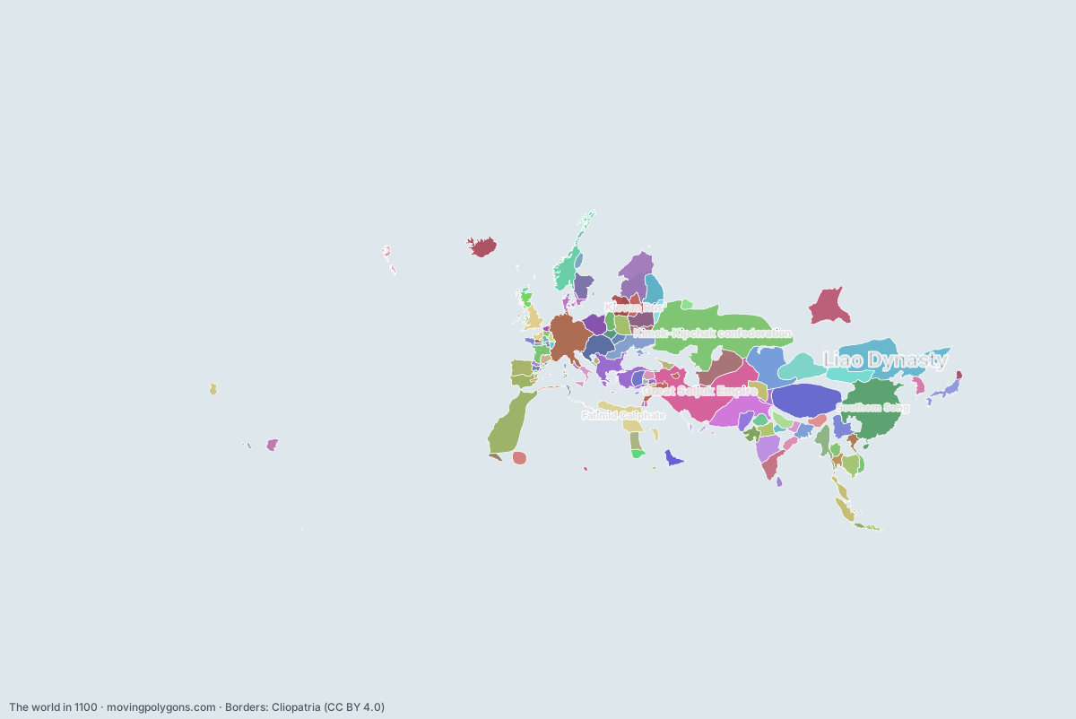
This map shows the 139 states and peoples the data has for the world in that year.
Watch these borders move
Play the changes on an animated map, in your browser. Free, no account needed.
States and peoples in the world in 1100
Largest first, by area on this map.
- Kimek-Kipchak confederation
- Great Seljuk Empire
- Southern Song
- Liao Dynasty
- Tibetans
- Almoravid Dynasty
- Kievan Rus'
- Ghaznavid Empire
- Holy Roman Empire
- Eastern Kara-Khanids
- Byzantine Empire
- Fatimid Caliphate
- Qocho Kingdom
- Khwarezmid Dynasty
- Novgorod Republic
- Yenisei Kyrgyz
- Western Chalukya Empire
- Western Xia
- Halych-Volhynia occupation
- Old Kingdom of Norway
- Srivijaya
- Kingdom of Hungary
- Pagan Kingdom
- Chola Empire
- Khmer Empire
- Kingdom of Dali
- Kingdom of Castile
- Principality of Chernigov
- Kingdom of Poland
- Principality of Rostov-Suzdal
- Hamdanid Emirates
- Norman England
- Heian Japan
- Lohara Dynasty
- Kingdom of Sweden
- Sena Dynasty
- Sind-Habbari Dynasty
- Gahadavala Dynasty
- Icelandic Commonwealth
- Principality of Kiev
- Principality of Polotsky
- Makuria
- Paramara Dynasty
- Chaulukya Dynasty
- Ghana Empire
- Najahid Dynasty
- Kamarupa Kingdom
- Principality of Smolensk
- Duchy of Aquitaine
- Chauhan Dynasty
- Eastern Ganga Kingdom
- Sultanate of Rum
- Goryeo
- Haripuñjaya
- Principality of Pereyaslavl
- Ngô Dynasty
- Lavo Kingdom
- Later Mayan City-States
- Principality of Volhynia
- Alodia
- Kingdom of Denmark
- Chámpa
- Norman Italy
- Principality of Ryazan
- Pala Empire
- Kashmir
- Kingdom of Alba
- Danishmendids
- Principality of Terebovlia
- Kingdom of Georgia
- Chandela Kingdom
- Puebloans - Chaco Regional System
- Viking settlements
- Takrur
- Volga Bulgaria
- Principality of Peremyshl
- County of Toulouse
- Uyunid Emirate
- Kingdom of Polonnaruwa
- Sunda Kingdom
- Jaemtland
- Northern Fujiwara
- Norse Greenland
- County of Blôis
- Duchy of Brittany
- Hammadid Dynasty
- Zirid dynasty
- Taifa of Zaragoza
- County of Champagne
- Kediri Kingdom
- Kingdom of Janggala
- Kingdom of France
- County of Vermandois
- Kingdom of Aragon
- Grand Principality of Serbia
- Kingdom of Arles
- Armenian Kingdom of Cilicia
- County of Flanders
- Taifa of Dénia
- Papal States
- County of Edessa
- Empire of Kanem
- County of Maine
- Kingdom of the Isles
- County of Anjou
- County of Nevers
- Kingdom of Jerusalem
- Classic Veracruz Culture
- Republic of Pisa
- Zagwe dynasty
- Kingdom of Duklja
- Giudicato of Cagliari
- County of Barcelona
- Republic of Venice
- Taifa of Albarracín
- Brythons
- Principality of Antioch
- Giudicato of Logudoro
- Taifa of Tortosa
- Ziyadid dynasty
- Kingdom of Powys
- Republic of Genoa
- Kingdom of Gwynedd
- County of Berga
- Toltec
- Early Balinese Kingdoms
- County of Urgell
- County of Rosellón
- Giudicato of Gallura
- Giudicato of Arborea
- County of Pallars Sobirà
- Taifa of Alpuente
- Zurayid dynasty
- Tamna
- County of Pallars Jussà
- County of Osona
- Chimor
- County of Ampuria
- Duchy of Naples
New on the map since 1050
Almoravid Dynasty · Khwarezmid Dynasty · Novgorod Republic · Halych-Volhynia occupation · Old Kingdom of Norway · Principality of Chernigov · Principality of Rostov-Suzdal · Norman England · Sena Dynasty · Gahadavala Dynasty · Principality of Kiev · Principality of Polotsky · Najahid Dynasty · Principality of Smolensk · Eastern Ganga Kingdom · Sultanate of Rum · Principality of Pereyaslavl · Lavo Kingdom · Principality of Volhynia · Kingdom of Denmark · Principality of Ryazan · Danishmendids · Principality of Terebovlia · Principality of Peremyshl · Uyunid Emirate · Kingdom of Polonnaruwa · Northern Fujiwara · Norse Greenland · Zirid dynasty · Grand Principality of Serbia · Armenian Kingdom of Cilicia · County of Edessa · Empire of Kanem · Kingdom of the Isles · Kingdom of Jerusalem · Kingdom of Duklja · Principality of Antioch · Kingdom of Powys · Zurayid dynasty
Gone from the map by 1150
Liao Dynasty · Eastern Kara-Khanids · Qocho Kingdom · Khwarezmid Dynasty · Kingdom of Poland · Principality of Polotsky · Kamarupa Kingdom · Duchy of Aquitaine · Norman Italy · Principality of Terebovlia · Principality of Peremyshl · Taifa of Zaragoza · County of Champagne · Kingdom of Janggala · County of Maine · County of Anjou · Kingdom of Duklja · Taifa of Albarracín · Taifa of Tortosa · Ziyadid dynasty · County of Berga · Taifa of Alpuente · County of Osona · Duchy of Naples
Animated maps of this time
The world in other years
Other regions in 1100
The outlines are coarse and follow the Cliopatria dataset: borders before modern surveys are estimates, and a blank area means the data has no state on record there, not that nobody lived there. A state that changed hands during the year can appear together with its successor.