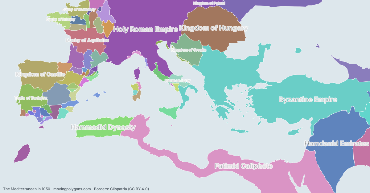
The Mediterranean in 1050
This map shows the 72 states and peoples the data has for The Mediterranean in that year.
Watch these borders move
Play the changes on an animated map, in your browser. Free, no account needed.
States and peoples in the Mediterranean in 1050
Largest first, by area on this map.
- Byzantine Empire
- Fatimid Caliphate
- Holy Roman Empire
- Hamdanid Emirates
- Kingdom of Hungary
- Kingdom of Castile
- Hammadid Dynasty
- Kievan Rus'
- Duchy of Aquitaine
- Taifa of Badajoz
- Kingdom of Croatia
- Buyid Dynasty
- Taifa of Toledo
- Kingdom of Georgia
- Duchy of Gascony
- Duchy of Normandy
- Duchy of Brittany
- Taifa of Zaragoza
- Kingdom of France
- Barghawata Conference
- County of Champagne
- County of Rouergue
- Norman Italy
- Emirate of Sicily
- County of Toulouse
- Kingdom of Poland
- Great Seljuk Empire
- County of Ribagorza
- Kingdom of Arles
- Taifa of Granada
- Taifa of Valencia
- Taifa of Dénia
- Papal States
- County of Nevers
- County of Vermandois
- County of Maine
- Taifa of Almería
- County of Anjou
- Taifa of Seville
- Taifa of Carmona
- Kingdom of Aragon
- Caliphate of Córdoba
- Giudicato of Cagliari
- County of Blôis
- Republic of Venice
- Taifa of Albarracín
- Taifa of Tortosa
- County of Barcelona
- Giudicato of Logudoro
- Taifa of Algeciras
- Principality of Salerno
- Republic of Genoa
- Taifa of Silves
- Taifa of Arcos
- County of Vexin
- Taifa of Saltés and Huelva
- County of Rosellón
- County of Urgell
- County of Berga
- Giudicato of Gallura
- Giudicato of Arborea
- County of Pallars Sobirà
- Taifa of Alpuente
- Republic of Pisa
- County of Osona
- Taifa of Santa Maria do Algarve
- County of Pallars Jussà
- Taifa of Niebla
- Taifa of Morón
- County of Ampuria
- Taifa of Ronda
- Duchy of Naples
New on the map since 1000
Hammadid Dynasty · Taifa of Badajoz · Taifa of Toledo · Kingdom of Georgia · Taifa of Zaragoza · Norman Italy · Great Seljuk Empire · Taifa of Granada · Taifa of Valencia · Taifa of Dénia · County of Nevers · Taifa of Almería · Taifa of Seville · Taifa of Carmona · Kingdom of Aragon · Taifa of Albarracín · Taifa of Tortosa · Taifa of Algeciras · Republic of Genoa · Taifa of Silves · Taifa of Arcos · Taifa of Saltés and Huelva · County of Pallars Sobirà · Taifa of Alpuente · Republic of Pisa · Taifa of Santa Maria do Algarve · County of Pallars Jussà · Taifa of Niebla · Taifa of Morón · Taifa of Ronda
Gone from the map by 1100
Taifa of Badajoz · Kingdom of Croatia · Buyid Dynasty · Taifa of Toledo · Duchy of Gascony · Duchy of Normandy · Barghawata Conference · County of Rouergue · Emirate of Sicily · County of Ribagorza · Taifa of Granada · Taifa of Valencia · Taifa of Almería · Taifa of Seville · Taifa of Carmona · Caliphate of Córdoba · Taifa of Algeciras · Principality of Salerno · Taifa of Silves · Taifa of Arcos · County of Vexin · Taifa of Saltés and Huelva · Taifa of Santa Maria do Algarve · Taifa of Niebla · Taifa of Morón · Taifa of Ronda
Animated maps of this time
- Rome — From Republic to Fall of Constantinople (509 BC – 1453 AD)
- The Holy Roman Empire and Its Lands, 962–1990
- Spread of Christianity, 30–2025
- Where elephants and mammoths lived, 21,000 years ago to today
- Italian Maritime Republics & Their Overseas Empires, 1000–1797
- Sinterklaas to Santa: the bearded gift-bringers, 343–2026
The Mediterranean in other years
Other regions in 1050
The outlines are coarse and follow the Cliopatria dataset: borders before modern surveys are estimates, and a blank area means the data has no state on record there, not that nobody lived there. A state that changed hands during the year can appear together with its successor.