A Light Beside Every Port
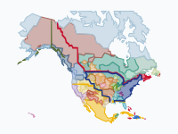
On 14 September 1716 the keeper George Worthylake lit the candles of Boston Light on Little Brewster Island, and for almost twenty years it was the only lighthouse on a coast that runs from the Florida Keys to Greenland. By 1900 there were more than 320 lighthouses and lightships, and set against the 7,200 recorded wrecks on this map they give a surprising answer: in Ireland a new light meant about 18% fewer wrecks nearby, in the North Sea about 12%, and here, taken as a whole, nothing at all.
The average hides two coasts. Near lightships and Canada's lights the wrecks did fall. Near US lighthouses they did not, because so many went up beside harbours whose traffic grew faster than any light could tame. Watch New York in the animation: the sea off Sandy Hook turns from orange to red in the 1850s, and from 1900 to 1920 it is the only magenta patch on the whole map, while one light after another is lit around it.
Treasure, Pirates and a Single Light
The map opens on 31 July 1715, when a hurricane drove eleven ships of the Spanish treasure fleet, carrying the silver of two fleets home from Havana, onto the reefs of Florida's east coast. About 1,000 people died, and divers are still raising its gold and silver along what is now called the Treasure Coast. In April 1717 Black Sam Bellamy's pirate flagship Whydah broke up in a nor'easter off Cape Cod and only two of her crew reached the beach alive. Her wreck, found in 1984, was the first pirate wreck ever identified beyond doubt, by a bell raised in 1985 that carries her name.
The French lit the first lighthouse in what is now Canada at Louisbourg in 1734, and Sambro Island at the mouth of Halifax Harbour, paid for by a tax on incoming ships in the very first act of Nova Scotia's new House of Assembly, was lit in 1759; it is the oldest working lighthouse in the Americas. In 1775 the whole coast still had eleven lights, and the worst disasters of the century were storms no light could have helped with. That September a hurricane fell on Newfoundland's fishing coast and killed at least 4,000 people, most of them fishermen; in 1782 a British convoy under Admiral Thomas Graves, bringing French prizes home from Jamaica, met a hurricane off the Grand Banks and lost some 3,500 sailors. The new US Congress took over the country's lighthouses in 1789, in only its ninth act.
Graveyards of the Atlantic
As the record fills up in the 19th century, the same places keep lighting up: the approaches to New York, where so many ships came ashore near Manasquan that the records simply call the stretch 'Squan Beach'; Cape Hatteras and the Outer Banks, the 'Graveyard of the Atlantic', with an estimated 2,000 ships lost; Charleston, where blockade runners piled up during the Civil War; Cape Cod and Nantucket; and in Canada Cape Sable Island, the Bay of Fundy, the Magdalen Islands, the Grand Banks and Sable Island, a sandbar in the open Atlantic with about 350 recorded wrecks between 1583 and 1947. The worst shoal was hard to mark at all: Diamond Shoals off Hatteras got a lightship in 1824, lost it in 1827, when it was wrecked near Ocracoke Inlet, and had none again until the 1890s.
Saving the people came long before saving the ships. In 1848, after Congressman William Newell reported that 158 sailing vessels had been lost on the New Jersey shore in ten years, Congress voted $10,000 for surfboats, rockets and boathouses, the first federal money for saving shipwrecked people. After the navy gunboat Huron went aground off Nags Head in November 1877, a week before the local station was manned for the season, and 98 men drowned, the Life-Saving Service became a separate bureau. From 1871 to 1914 its surfmen, on all American coasts, went to the aid of 28,121 vessels and 178,741 people, and 1,455 lives were lost. The ships still went aground; far fewer of the people on them died.
Disasters and the Lights They Built
Some lights were a direct answer to a disaster. In February 1860 the Allan Line steamer Hungarian struck Cape Ledge off Cape Sable Island at night and broke up with all 205 aboard; the wreck finally moved the government to act on years of petitions, and the first Cape Sable lighthouse was lit in November 1861. More often the answer was a rule or a machine: steamer lanes across the North Atlantic, proposed by Matthew Fontaine Maury after the Collins liner Arctic sank off Newfoundland in 1854 with no woman or child among the survivors, and the world's first steam fog alarm, installed by Robert Foulis on Partridge Island in the Bay of Fundy in 1859, where fog, not darkness, was the danger.
Nor could lights stop the great wrecks of the steam age. The White Star liner Atlantic misjudged her position on the way into Halifax in 1873 and drove onto the rocks with at least 535 dead, and the excursion steamer General Slocum burned in New York's East River in 1904 with 1,021 dead, most of them women and children, still the deadliest disaster in New York harbour.
What the Numbers Say
The test is the one used on the sister maps: for about 100 lights with a researched first-lit date, count the recorded losses within 10 and 15 km in the 20 years before and after the light was lit, and compare the 'after' number with what the trend for the whole coast predicted. Pooled, it lands within a few per cent of the prediction (5% below at 10 km, 6% above at 15 km). Near the lightships it was 11 to 14% below, near Canada's lights roughly a quarter below. Cape Sable had 48 wrecks nearby in the 20 years before its light and 30 after, when 63 were expected; Baccaro Point (1851) went from 65 to 32 when 81 were expected, and the Bishop and Clerks lightship in Nantucket Sound (1856) from 11 to none.
Near US lighthouses the count rose: 7% above the trend at 10 km, 37% above it at 15 km. Many were lit beside ports that grew far faster than the coast as a whole. Coney Island's light at the entrance to New York Harbor (1890) had 32 wrecks nearby before and 124 after, and Stepping Stones in Long Island Sound (1877) went from 1 to 14. A light does not prevent collisions in a crowded channel. And the American result is firmer than it looks: lights were usually built after a bad run of wrecks, which tends to be followed by a calmer one anyway, and even with that tailwind the US lighthouses show no drop.
Radio, Ice and the Long Decline
In this record the peak is the 1860s and 1870s, at about 70 recorded losses a year. The count does not fall when radio arrives: it stays at about 60 a year through the 1900s and 1910s, halves to about 36 a year in the 1920s and is down to a handful a year after 1950. What radio changed first was what a wreck meant. In January 1909 the White Star liner Republic, rammed in fog off Nantucket, stayed afloat for a day while her operator Jack Binns sent the CQD distress call; ships homing on the call took off about 1,500 people, and six died. After the Titanic struck an iceberg south of the Grand Banks in April 1912 and about 1,500 died, the first SOLAS convention brought lifeboats for all, round-the-clock radio watches and the International Ice Patrol. Two years later, in peacetime fog in the St Lawrence, the Empress of Ireland was rammed by a collier and sank in fourteen minutes with 1,012 dead, the worst peacetime wreck in Canadian history.
The years around 1900 need a warning. Between 1891 and 1913 Wikipedia's lists of shipwrecks are yearly instead of monthly. On this coast they keep the American wrecks (there are even more of them than in the 1870s), but the waters of Canada and Newfoundland almost disappear: from about 150 to 200 recorded losses in each five years of the 1870s to between 10 and 25 in each five years from 1895 to 1914. So when Halifax, Cape Race and the Newfoundland coast go quiet on the map between about 1890 and 1915, that is a gap in the record, not a calm sea. Whether the American coast really lost more ships around 1905 than in the 1870s, or the yearly lists simply lean on American newspapers, this record cannot say.
The world wars bring the last spikes. In December 1917 the munitions ship Mont-Blanc exploded in Halifax harbour and killed at least 1,782 people. Between January and August 1942 the map records 168 losses as U-boats worked along a coast that was not yet blacked out, picking off tankers silhouetted against the lights of seaside towns. The war itself brought loran (1942) and radar (the Andrea Doria and the Stockholm still collided off Nantucket in 1956, each having seen the other on its screen). The last US lightship left the Nantucket Shoals in 1983, GPS became fully operational in 1995, and in December 2023 Sally Snowman retired as keeper of Boston Light, the last American lighthouse with an official keeper, 307 years after Worthylake lit the first candles.
How to Read the Map
The hotspots are counted over the ten years before each date: orange for 0.25 or more recorded losses per 100 km², red for 0.7 or more, magenta for 1.8 or more. The thresholds are far lower than on the Irish and North Sea maps, so compare patterns between the maps, not colours. A yellow dot labelled 'lit' has a researched first-lit date; one labelled 'tower of' carries the year of the present tower, so the first light there may be older. The 87 pins tell the big stories; the small dots are a selection of about 1,200 wrecks, and clicking one opens its entry. The coast runs from 24° to 66° north, so the map opens zoomed far out on a wide screen.
Each wreck sits at the town, cape or shoal its entry names, so positions are approximate, and wrecks on large features such as the Grand Banks are spread over that area. The lists record only part of all losses, Canadian waters are thin between about 1890 and 1915, and after 1950 the empty sea means few recorded losses, not none.
How the Map Was Made
The wrecks come from the English Wikipedia's 'List of shipwrecks in …' pages (CC BY-SA 4.0), the same 245,000 entries we read for the North Sea map, placed by the coordinates of the places each entry links to. A link after 'departed from' or 'bound for' names a port, not the place of loss, so it was not used, and 695 ships sunk on purpose as blockships, targets or artificial reefs were left out. That leaves about 7,200 total losses and 3,900 other casualties. The 577 lights combine first-lit dates researched from lighthousefriends.com, Russ Rowlett's Lighthouse Directory and the US Coast Guard's lightship station index with OpenStreetMap lighthouses (ODbL) dated through Wikidata; only researched dates went into the analysis. The stories draw mainly on Wikipedia, the National Park Service, the US Coast Guard historian, Parks Canada and Memorial University's Maritime History Archive.
Chronological Timeline
- 31 July 1715 — Hurricane wrecks the Spanish treasure fleet off Florida
- 14 September 1716 — Boston Light, America's first lighthouse
- September 1775 — Hurricane kills at least 4,000 in Newfoundland
- 7 August 1789 — US Lighthouse Act
- 1848 — First federal money for life-saving, on the New Jersey shore
- 1860–1861 — The Hungarian lost off Cape Sable; Cape Sable lighthouse lit
- 1860s–1870s — Peak of the record: about 70 recorded losses a year
- 1878 — US Life-Saving Service made a separate bureau
- January 1909 — The Republic: first great rescue by radio
- 15 April 1912 — The Titanic sinks south of the Grand Banks
- 6 December 1917 — The Halifax Explosion
- 1942 — U-boats off the American coast; loran
- 1983 — The last US lightship leaves the Nantucket Shoals
- 30 December 2023 — Boston Light's last keeper retires
Watch three centuries of wrecks come and go from Florida to Greenland in the interactive map, click any dot for its entry, or embed the map on your own site.
Explore the full interactive map →Ireland, where the lights come out best: five coal fires in 1700, the disasters that built Fanad Head and Fastnet, and 18,000 records from the national wreck inventory.
Read about the Ireland map →The North Sea, where the lights did a little: the colliers' road from the Tyne to the Thames, the first lightships and the Lutine, from the Christmas storm at Texel in 1593 to the Fremantle Highway in 2023.
Read about the North Sea map →Frequently asked questions
- Where did most shipwrecks happen on the East Coast of North America?
- In the records behind this map, the biggest clusters are in the approaches to New York (Sandy Hook, Long Island and the New Jersey shore), around Cape Hatteras and the Outer Banks, off Charleston during the Civil War, and around Cape Cod and Nantucket. In Canada the worst places were Cape Sable Island off Nova Scotia, the Bay of Fundy, the Magdalen Islands, the Grand Banks of Newfoundland and Sable Island. From 1900 to 1920 the approaches to New York were the densest wreck area on the whole map.
- What is the Graveyard of the Atlantic?
- It is a nickname for the waters off North Carolina's Outer Banks, where an estimated 2,000 ships have been lost, with Cape Hatteras and Diamond Shoals at their centre. The same name is used for Sable Island off Nova Scotia, a sandbar in the open Atlantic where about 350 wrecks were recorded between 1583 and 1947.
- What was the first lighthouse in North America?
- Boston Light, on Little Brewster Island at the entrance to Boston Harbor, first lit by keeper George Worthylake on 14 September 1716. The first lighthouse in what is now Canada was lit by the French at Louisbourg on Cape Breton Island in 1734, and the Sambro Island light at the mouth of Halifax Harbour, first lit in 1759, is the oldest working lighthouse in the Americas.
- Did lighthouses reduce shipwrecks on the East Coast?
- Taken together, no. Across about 100 lights with researched first-lit dates, the recorded wrecks within 10 to 15 km in the 20 years after a light was lit were within a few per cent of what the trend for the whole coast predicted. Near lightships they were 11 to 14% below the trend and near Canada's lights roughly a quarter below it: Cape Sable went from 48 wrecks to 30 when 63 were expected. Near US lighthouses they were not lower at all, because many stood beside fast-growing ports: at Coney Island, at the entrance to New York Harbor, the count went from 32 to 124.
- Why did shipwrecks on the Atlantic coast decline?
- In this record the peak is the 1860s and 1870s, at about 70 recorded losses a year; the count stays at about 60 a year into the 1910s, halves in the 1920s and is down to a handful a year after 1950. Steam and steel ships, radio, the International Ice Patrol, loran (1942), radar and GPS all arrived in that span, and the record cannot separate them. What radio and the life-saving crews changed first was the death toll: in 1909 the Republic sank and about 1,500 people were saved.
- What was the deadliest shipwreck off the Atlantic coast of North America?
- The worst storm on the map is the Newfoundland hurricane of September 1775, which killed at least 4,000 people, most of them fishermen, and the worst naval loss is Admiral Graves's convoy, caught by a hurricane off the Grand Banks in 1782 with some 3,500 sailors dead. Of single ships, the Titanic (1912) is the deadliest, with about 1,500 dead; the General Slocum fire of 1904 (1,021 dead) is the deadliest disaster in New York harbour, and the Empress of Ireland (1914, 1,012 dead) the worst peacetime wreck in Canadian history.
- Is there an animated map of shipwrecks and lighthouses on the East Coast?
- Yes. Moving Polygons has a free animated map that plays from 1715 to 2026, from the Florida Keys to Greenland, with red hotspots for the wrecks of each decade, 577 lighthouses and lightships that appear when they were first lit, about 1,200 individual wrecks you can click, and 87 pins for the big stories. Sister maps cover Ireland and the North Sea. You can watch them and embed them on your own website.
Text version of the map (timeline, layers and events): Markdown