The Fourth-Largest Lake on Earth
The fishing boats of Moynaq lie in rows on dry sand, and the nearest open water is well over 100 km away. In 1960 they worked the fourth-largest lake on Earth, and this map shows, frame by frame, where its water went.
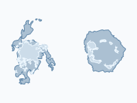
The Aral Sea lies in the desert on the border of Kazakhstan and Uzbekistan. In 1960 it covered about 67,500 km² at a level of 53.4 m, and had more than a thousand islands and canneries in Aralsk in the north and Moynaq in the south. For half a century its level had hardly moved: two rivers, the Amu Darya and the Syr Darya, brought in about as much water as the desert sun took out. By the last frame, in September 2026, about 4,900 km² of open water remains, 7% of the 1960 sea.
Cotton in the Desert
From the early 1960s Soviet planners greatly expanded irrigated cotton and rice in the deserts of Central Asia, and the water came from the Aral's only two rivers. Their inflow to the sea fell from about 43 km³ a year in the 1960s to about 17 km³ in the 1970s and almost nothing in the early 1980s. The biggest single drain was the Karakum Canal, which carried Amu Darya water westward into Turkmenistan. The sea fell by about 20 cm a year in the early 1960s and by more than half a metre a year from the mid-1970s. The east and south were shallow, so there the water withdrew by tens of kilometres, while the deep western trench under the Ustyurt cliffs hardly changed shape: on the map the sea seems to be pulled north-west, away from the river deltas.
Ships on the Sand
As the water shrank it grew saltier: about 10 grams of salt per litre in 1960, 14 in 1976 and 30 by 1989. The native freshwater fish stopped spawning and then died out, and 20 of the 24 native species disappeared. The catch had peaked at about 48,000 tonnes in 1957 and was still 34,000 tonnes in 1961; as the salt rose it fell to about 15,000 tonnes in 1971 and under 3,000 tonnes by 1980, and by the early 1980s the commercial fishery was gone, with some 60,000 jobs.
Moynaq, a fishing port and cannery town on the southern shore, saw its boats stranded on the sand in the 1970s and 1980s. By 1988 the town was tens of kilometres from the sea, and the rusting hulls below the town's memorial became the best-known image of the disaster. Aralsk, the port in the north, was 75 km from the water in 2001, according to the World Bank.
What the Dry Sea Did
None of this came as a surprise in Moscow. Soviet water planners expected the sea to shrink once the rivers went to the fields, some called the Aral a mistake of nature, and in 1968 an engineer wrote that its evaporation was obvious to everyone and inevitable. The wisdom of the day held that the crops were worth more than the fish. The rescue stayed on paper: a scheme to send part of the Ob and the Irtysh from Siberia to Central Asia, with refilling the Aral among its aims, was enormously expensive and unpopular in Russia, and in August 1986 Pravda and Izvestia announced that work on it had stopped. By then the sea was more than 10 m lower than in 1960.
The people who stayed paid for it. Storms lift salt, sand and dust laced with the pesticides of the cotton fields off the old seabed and drop them on fields and towns, and without the sea to soften it the winters became colder and the summers hotter and drier. In Karakalpakstan, the Uzbek autonomous republic on the southern shore, surveys of the 1990s and 2000s found anaemia in more than half of young children (53.6% of under-fives in 2002), infant mortality of 56 per 1,000 in 2006 (with neighbouring Khorezm), drinking water salty enough to harm children's kidneys, and DDT and other pesticide residues in mothers' blood and breast milk. Whether the dust itself damaged children's lungs is less clear: a review of the research published in 2010 found that evidence inconclusive. The dust blows from the Aralkum, the desert on the old seabed, and the map's pin in the 2009 frame measures it: about 59,000 km² then, about 63,000 km² in 2026. Uzbekistan and Kazakhstan are planting saxaul and other hardy shrubs on it to hold down the salt; Uzbekistan began a large programme in December 2018.
One Sea Becomes Two, Then Three
When the level fell to about 40 m, the floor of the Berg Strait between Kokaral and the mainland emerged, and the Aral broke into the Small (North) Aral, fed by the Syr Darya, and the Large (South) Aral, fed by the Amu Darya. Sources date the split between autumn 1987 and 1989.
Barsakelmes, a nature reserve since 1939, was joined to the mainland in the late 1990s. Vozrozhdeniya (Rebirth) Island held the Soviet open-air biological weapons test site Aralsk-7, abandoned in 1992; between summer 2000 and summer 2001 the strait to its south dried up, and the old test ground could be reached on foot. The former island then divided the South Aral into a narrow, deep western basin and a broad, shallow eastern one, and in the 2008 frame they are two separate lakes.
A Dike for the North
In August 1992 local authorities piled up a dike of sand and reeds across the old strait to keep the Syr Darya's water in the North Aral. It had no spillway, broke several times and was washed away for good in a storm on 20 April 1999. With World Bank support, Kazakhstan then built a proper one: a 13 km dike with a gated spillway, closed in August 2005. The North Aral rose from about 40 m to its 42 m design level by March 2006, and its salinity fell from over 20 g/L in 2001 to under 10 g/L in 2010.
With fresher water, bream, pike-perch, carp and roach came back. The catch rose from about 700 tonnes in 2005 to about 7,000 tonnes in 2016, and fish is again processed in Aralsk, although in 2018 the town's old harbour was still about 20 km from the water. In May 2025 Kazakhstan and the World Bank began preparing a second phase, a higher dike that would hold the North Aral at about 44 m and about 3,900 km²; as of March 2026 the plan awaited government review, with work planned for 2026–2029.
The South Keeps Shrinking
The dike that saved the north also cut the south off from the Syr Darya's overflow. The eastern basin was almost dry in 2009, refilled in the wet year 2010, and in summer 2014 was completely dry for the first time in modern history (Philip Micklin thought probably for the first time in about 600 years). It flooded thinly again in wet years, most clearly in 2017, and from 2019 the map shows no eastern water at all; since then more than half of the open water is the North Aral. The western basin's level has fallen by more than 26 m since 1960, and its water holds well over 100 grams of salt per litre. By volume even less is left than by area: the CAWater-Info tables give about 69 km³ for 2018, some 6% of the 1,083 km³ of 1960.
How to Read the Map
The pale shape is the sea of 1960, now mostly dry seabed; islands are drawn in the same colour. The blue is the water at the late-summer low, so every frame is dated 1 September, on a satellite basemap of today's land. The frames before 1986 are five years apart (1960 to 1980, then 1982 and 1984); from 1986 there is one a year, except 1988, 1995 and 1997, for which too few satellite images exist. The caption gives the area of open water, measured on the map's shapes, and its share of the 1960 sea; click a pin for the story and its sources.
The map shows open water only. Lakes under about 40 km² are left out, and so are the lakes of the Amu Darya delta, which canals keep full; shores are smoothed to about 250 m, and wet salt flats do not count as water. The 1986 and 1987 frames have so few images that their shapes lean on 1989, so the fall from 1984 to 1986 looks too steep and the years to 1989 too flat, while the measured level fell steadily; the Berg Strait, by then too narrow for the method, is drawn about 0.8 km wide in those two frames. Published areas differ by a few per cent in most years, and by much more when the eastern basin holds a thin sheet of water: for 2018 the map measures 8,900 km², the CAWater-Info tables 6,990 km².
How the Map Was Made
There are no usable satellite images of the whole sea from before the mid-1980s, so the frames for 1960–1984 are reconstructions: each shore is the contour of the Copernicus 90 m elevation model, measured over the dry seabed in 2011–2015, at the sea level published for that year in the CAWater-Info tables (53.4 m in 1960, 42.75 m in 1984). The map's 1960 shape measures about 67,600 km², close to the 67,499 km² that Micklin and colleagues give for 1 January 1960, and the captions' percentages are shares of that shape.
The frames for 1986–2021 come from Landsat, through the yearly classification of the JRC Global Surface Water dataset (Pekel et al. 2016): water that was present all year. The frames for 2022–2026 come from Sentinel-2 images of August and September, with a water index (MNDWI above 0.3) whose threshold was chosen to reproduce the JRC result for 2021. The pins draw on Micklin (1988, 2016), Aladin, Ermakhanov and Izhitskiy and their colleagues, the World Bank's completion report for the dike and NASA Earth Observatory; the health figures come from a review of children's health in the Aral Sea area by Crighton and colleagues (International Journal of Public Health, 2010).
Chronological Timeline
- 1960 — About 67,500 km² at 53.4 m: the fourth-largest lake on Earth
- Early 1960s — Soviet irrigation of cotton and rice starts taking the water of the Amu Darya and Syr Darya
- August 1986 — Moscow stops work on diverting Siberian rivers to Central Asia
- 1987–1989 — The Berg Strait dries and the sea splits into the North and the South Aral
- August 2005 — Kazakhstan closes the 13 km Kokaral dike; the North Aral reaches 42 m by March 2006
- Summer 2014 — The eastern basin is completely dry for the first time in modern history
- May 2025 — Kazakhstan and the World Bank begin preparing a higher dike for the North Aral, to about 44 m
- September 2026 — About 4,900 km² of open water is left, 7% of the 1960 sea
Watch the Aral Sea shrink frame by frame, click a pin for the story and its sources, or embed the map or export it as a GIF for lessons and talks.
Explore the full interactive map →The same story the other way round: how the Netherlands won land from the sea, dike by dike and polder by polder.
Read about the Netherlands map →Frequently asked questions
- Why did the Aral Sea dry up?
- The Aral Sea had only two rivers, the Amu Darya and the Syr Darya. From the early 1960s Soviet irrigation schemes took their water to grow cotton and rice in the deserts of Central Asia. The inflow fell from about 43 km³ a year in the 1960s to about 17 km³ in the 1970s and almost nothing in the early 1980s, while evaporation carried on, so the sea shrank. The planners expected this: the wisdom of the day held that the crops were worth more than the fish.
- How big was the Aral Sea, and how much is left?
- In 1960 it was the fourth-largest lake in the world, after the Caspian Sea, Lake Superior and Lake Victoria, with about 67,500 km² of water at a level of 53.4 m. Measured on Sentinel-2 images of late summer 2026, about 4,900 km² of open water is left, 7% of the 1960 surface. By volume even less remains: in 2018 the CAWater-Info tables give about 69 km³, some 6% of the 1,083 km³ of 1960.
- Where is the Aral Sea, and what is the ship graveyard at Moynaq?
- The Aral Sea lies in the desert of Central Asia, on the border of Kazakhstan in the north and Uzbekistan's autonomous republic of Karakalpakstan in the south. Moynaq was a fishing port and cannery town on its southern shore. As the water withdrew in the 1970s and 1980s the boats were left stranded on the sand; by 1988 the town was tens of kilometres from the sea, and in 2026 the nearest open water is well over 100 km away. The rusting hulls below the town's memorial are the best-known image of the disaster.
- What did the drying of the Aral Sea do to the people around it?
- The fishery that had employed some 60,000 people was gone by the early 1980s. Storms blow salt, sand and pesticide-laden dust off the dry seabed onto fields and towns, and without the sea the winters became colder and the summers hotter and drier. In Karakalpakstan surveys found anaemia in more than half of young children (53.6% of under-fives in 2002), infant mortality of 56 per 1,000 in 2006 (with neighbouring Khorezm), drinking water salty enough to harm children's kidneys and residues of DDT and other pesticides in mothers' blood and breast milk.
- What is the Kokaral dike and did it work?
- The Kokaral dike is a 13 km dike with a gated spillway across the old Berg Strait, closed by Kazakhstan in August 2005 with World Bank support. It keeps the Syr Darya's water in the North Aral. The level rose from about 40 m to the 42 m design level by March 2006, salinity fell from over 20 g/L in 2001 to under 10 g/L in 2010, and the fish catch rose from about 700 tonnes in 2005 to about 7,000 tonnes in 2016. The South Aral did not benefit and kept shrinking.
- Is the Aral Sea coming back?
- Only the northern part. The North Aral has been held at about 42 m since 2006. In May 2025 Kazakhstan and the World Bank began preparing a second phase that would raise it to about 44 m and about 3,900 km²; as of March 2026 the plan was awaiting government review, with work planned for 2026–2029. The South Aral is still shrinking: its eastern basin has been dry in most years since 2014, and its western basin is a narrow lake far saltier than the ocean.
- Is there an animated map of the Aral Sea shrinking?
- Yes. Moving Polygons has a free animated map of the Aral Sea from 1960 to 2026 on a satellite basemap. The pale shape is the sea of 1960 and the blue is the water, in 45 frames: five years apart from 1960 to 1980, then 1982 and 1984, and one a year from 1986 except 1988, 1995 and 1997. Each caption gives the area and the share of the 1960 sea, and pins tell the main events. You can watch it and embed it on your own website.
Text version of the map (timeline, layers and events): Markdown