A Map Sewn, Not Drawn
Long before printed atlases, history was told in thread. The Bayeux Tapestry stitched the Norman conquest onto linen, and the opening titles of House of the Dragon tell the Targaryen family history the same way: long silky stitches, dark outlines, red dye seeping into the cloth, a camera gliding low over it all. Tapestry is a new Moving Polygons map style built on that idea. It turns an animated history map into embroidery on a single linen cloth.
Thread, Linen and Dye
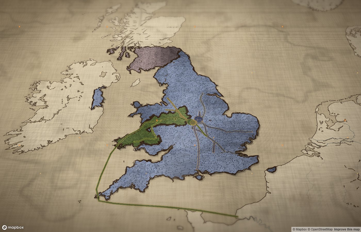
Land and sea are one cream cloth, the sea a shade darker as if dyed with weak walnut. Coasts and rivers are stitched in dark thread. Every territory is raised embroidery: long stitches that run in their own direction in patches, like real hand-worked satin stitch, outlined in dark stem stitch and casting small shadows on the linen. Over everything lies the weave of the cloth, with folds, grime and the occasional needle hole. Colours are toned toward old sepia thread, so a map reads like an heirloom rather than a screen.
The camera is tilted, the edges of the view fall out of focus, a vignette darkens the corners and embers drift across the screen. The interface around the map takes on the parchment look of our vintage style.
Unpicked and Stitched Anew
On other map styles a border slides from one position to the next. On a tapestry, that would tear the cloth. Instead, when a territory changes hands the old stitches are pulled out end first, leaving needle holes and a faded stain. The new colour seeps into the linen like dye with a tide line at its edge, and then the new territory is stitched in, thread by thread, with a glint of gold on each stitch just pulled through. The changes start at the bottom of the changed area and move up in blotchy patches, the way a needlewoman would work. Each change takes about three seconds at normal speed.
Armies on the Cloth
Restitching works for kingdoms but not for armies. A token that marches every day would be unpicked and restitched at every step and blink from place to place. So small layers that move, such as armies, fleets and routes, are drawn as appliqué pieces: patches of cloth laid on top of the embroidery, edged in a running stitch of their own colour worked with gold. They slide along their routes like on any other map, and the linen weave and folds lie over them too, so they still belong to the cloth.
The first map in the Tapestry style shows exactly that mix. In The Wars of the Roses (1455–1487), the counties of England and Wales are stitched in the colour of the side whose lords dominated them: Lancastrian red, Yorkist slate blue, Tudor moss green. Over them, the armies of Edward IV, Warwick the Kingmaker, Margaret of Anjou, Richard III and Henry Tudor slide along their marches day by day, from St Albans to Towton, Barnet, Tewkesbury, Bosworth and Stoke Field.
When to Use It
- Dynastic and medieval history: succession wars, kingdoms, conquests and campaigns
- Clearly different, fairly saturated colours such as oxblood, ochre, slate blue, moss green and black; near-identical tints merge in thread
- Large territorial changes, with armies, fleets and routes as moving pieces on top
- Regional and continental maps in Mercator; the style does not support world projections
To use it, open a map in the editor and choose Tapestry from the map styles. Maps built with the Moving Polygons map skill for Claude can also ask for it directly with the map style tapestry.
See the Tapestry style in motion: the armies of York, Lancaster and Tudor marching across an embroidered England.
Watch The Wars of the Roses →Frequently asked questions
- What is the Tapestry map style?
- Tapestry is a Moving Polygons map style that draws the map as embroidery on linen. Land and sea are one cream cloth with folds, coasts and rivers are stitched in dark thread, and every territory is raised thread in long stitches with a dark outline.
- What inspired the Tapestry map style?
- The opening titles of House of the Dragon, which tell the Targaryen family history as an embroidered tapestry with long silky stitches, dark outlines and red dye seeping into the cloth, filmed with a low tilted camera.
- How do borders change on a tapestry map?
- Instead of borders sliding, the old stitches are pulled out, leaving needle holes and a faded stain, the new colour seeps into the linen like dye, and then the new territory is stitched in thread by thread. Each change takes about three seconds at normal speed.
- Can a tapestry map show moving armies?
- Yes. Small layers that move, such as armies, fleets and routes, are not stitched into the cloth but drawn as appliqué pieces edged in a running stitch. They slide along their routes like on any other map, while the territories underneath keep the stitching transitions.
- Which maps suit the Tapestry style?
- Tapestry is made for dynastic and medieval history: succession wars, kingdoms and conquests. Clearly different, fairly saturated colours such as oxblood, ochre, slate blue and moss green work best, because thread colours are toned toward old sepia. It works on Mercator maps, not on world maps.
- Is there an example of an animated map in the Tapestry style?
- Yes. The Wars of the Roses (1455–1487) on Moving Polygons is the first map in the Tapestry style. It follows the armies of York, Lancaster and Tudor day by day from St Albans to Stoke Field, with the counties stitched in the colour of the side that dominated them.
Text version of the map (timeline, layers and events): Markdown