A Border Drawn by Sieges
Drive south from Breda towards Antwerp and somewhere past Hazeldonk you cross from the Netherlands into Belgium without crossing a river, a ridge or anything else a geographer would call a frontier. The line is the front of a war: roughly where the armies of the Dutch Republic and the king of Spain stood when they made peace at Münster in 1648, after a revolt that began with a handful of rebel towns in Holland and Zeeland and that nobody at the start meant to end in two countries.
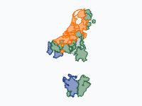
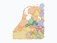
The map follows that war district by district, from Louis of Nassau's invasion in May 1568 to the ratification of the peace on 15 May 1648. The orange of the rebels flares up in 1572, covers half the country in 1579, shrinks back to the rivers by 1589 and then creeps south again into Brabant, Zeelandic Flanders and Limburg until the line freezes.
1568–1576: Holland and Zeeland Against the Rest
The war is dated from Heiligerlee in Groningen, where on 23 May 1568 Louis of Nassau and his brother Adolf beat the royal stadholder, the count of Aremberg; both Adolf and Aremberg were killed. It won nothing on the ground. Two weeks later the Duke of Alba had the counts of Egmont and Horne beheaded in Brussels, and in July he destroyed Louis's army at Jemmingen. The first frame of the map is Spanish red but for Louis's foothold in Westerwolde.
The revolt that lasted began on 1 April 1572, when the Sea Beggars, Protestant privateers under Willem Bloys van Treslong and the lord of Lumey, took Brielle. Vlissingen rose five days later, and over the summer town after town in Holland opened its gates to William of Orange's men; on 19 July deputies of twelve towns met at Dordrecht and recognised Orange as their stadholder. That summer also brought gains that did not last: Louis of Nassau held Mons, Orange's brother-in-law Van den Bergh took Zutphen, Kampen and Zwolle. In the autumn Alba's army took them back with deliberate cruelty, sacking Mechelen and Zutphen and massacring Naarden on 1 December 1572. On the map the orange of July shrinks back to Holland and Zeeland by December.
There it held, helped by the water. Haarlem fell on 13 July 1573 after a seven-month siege, but Alkmaar flooded the land around it and the Spanish gave up on 8 October ('Bij Alkmaar begint de victorie'), and on 3 October 1574 Louis de Boisot's fleet sailed over the flooded polders to relieve Leiden, a day the town still celebrates. The map leaves the water of the time unpainted: the Zuiderzee, the Haarlemmermeer, the Noord-Holland lakes drained in the seventeenth century and the drowned lands of Zeeland.
1576–1581: The Whole Country, Briefly
What turned a provincial rebellion into a national one was Spain's bankruptcy. Unpaid since the death of the governor Requesens, the Spanish troops mutinied, and on 4 November 1576 they sacked Antwerp for three days. Four days later the States-General and Orange's Holland and Zeeland signed the Pacification of Ghent to drive the soldiers out. On the map almost the whole of the Low Countries turns yellow, the colour for provinces that sided with the States-General without joining the revolt itself; only Luxembourg, some garrison towns and, for a few more weeks, the north under the royal stadholder Robles stay red.
The unity lasted barely two years. The new governor, Don John of Austria, seized the citadel of Namur in July 1577 and on 31 January 1578 routed the States army at Gembloux; after his death on 1 October his nephew Alexander Farnese, prince of Parma, took over. Religion did the rest. On 6 January 1579 the Catholic Walloon provinces, Artois, Hainaut and Walloon Flanders, formed the Union of Arras to make their peace with the king, and on 23 January the northern provinces bound themselves together in the Union of Utrecht. This is the moment the map turns into two colours, red in the south and orange from the Flemish coast to Groningen. In March 1580 the stadholder of the north, Rennenberg, went over to the king with Groningen, and on 26 July 1581 the States-General declared Philip II deposed in the Act of Abjuration.
1579–1609: Parma Rolls the Front Back to the Rivers
Parma worked methodically, one fortified town at a time. Maastricht was stormed on 29 June 1579, Tournai fell in 1581, Oudenaarde in 1582, Dunkirk, Nieuwpoort and Zutphen in 1583, Ypres, Bruges and Ghent in 1584, Brussels and Nijmegen in March 1585. On 17 August 1585 Antwerp surrendered after Parma had closed the Scheldt with a bridge of ships, and many of its Protestant merchants left for Holland. William of Orange had been murdered in Delft a year earlier. By 1589 the orange on the map is pressed back behind the great rivers, with outposts at Ostend, Axel and Bergen op Zoom.
The rivers saved the north, and so did Spain's other wars: in 1588 Parma's army waited in vain for the Armada, and from 1590 he was sent into France. Maurice of Nassau, the States' young commander, used the respite. Seventy soldiers hidden in a peat barge took Breda on 4 March 1590; Zutphen, Deventer and Nijmegen followed in 1591, Steenwijk and Coevorden in 1592, Groningen in July 1594, and Twente and Lingen in the autumn of 1597. On the map the north-east turns orange again in steps. Spinola won back Oldenzaal, Lingen and Groenlo in 1605–06, but by the Twelve Years' Truce of 9 April 1609 both sides were exhausted. In the east the front still ran through Twente and the Achterhoek, where Spain held Oldenzaal until 1626 and Groenlo until 1627.
1621–1648: Frederick Henry Pushes South
After the Truce the fighting moved into Brabant and the Maas valley. Spinola starved out Breda in 1625, but Maurice's half-brother Frederick Henry answered with a series of sieges the map shows as orange bites out of the Spanish south: 's-Hertogenbosch, which he took on 14 September 1629 after draining the marshes around it, Venlo, Roermond and Maastricht in the summer of 1632, Breda for good in October 1637, then Sas van Gent in 1644 and Hulst in 1645. Venlo and Roermond were lost again in 1637 and were still Spanish at the peace.
From 1635 France fought as the Republic's ally, and the blue of French conquests spreads over Artois and Flanders: Hesdin in 1639, Arras in 1640, Gravelines in 1644, Kortrijk and Dunkirk in 1646. The French successes worried the Dutch: a weak Spain on their southern border was better than a strong France, and the States-General hurried to a separate peace.
Münster, and the Line on Today's Map
The Peace of Münster was signed on 30 January 1648 and ratified on 15 May. Spain recognised the United Provinces as a free and sovereign republic, and each side kept what it held. The Republic's conquests south of the rivers became the Generality Lands: States Brabant around Breda, Bergen op Zoom and 's-Hertogenbosch, States Flanders around Sluis, Axel and Hulst, and Maastricht with part of the Lands of Overmaas. They were governed from The Hague with no vote of their own, their mostly Catholic people lived as second-class subjects until 1796, and the Scheldt stayed closed to Antwerp's trade.
In Zeelandic Flanders and Brabant that line of 1648, with small corrections, is the border between the Netherlands and Belgium today: it was the border of the Spanish and then Austrian Netherlands, and when Belgium broke away in 1830 the Treaty of London of 1839 put the frontier back on it. In Limburg the war only started the process. The Lands of Overmaas were partitioned in 1661, Upper Guelders with Venlo and Roermond was divided in 1713, and the province of Limburg was split between the two countries in 1839. The present border there is the descendant of the front, redrawn three times.
How to Read the Map
Red is the Spanish crown and the royalists; orange the rebels and, from 1588, the sovereign Republic of the United Provinces; yellow the provinces that sided with the States-General under the Pacification of Ghent (1576–79); blue is France and its conquests, from Cambrai under Anjou (1581–95) to Artois and Flanders (1637–48); grey the neutral Prince-Bishopric of Liège. Red patches inside France are Spanish conquests such as Calais (1596–98). Pins are coloured by the side that prevailed, purple for political events; the small dots are lesser sieges and battles. The bar at the bottom compares soldiers under arms on each side, with estimates shown as a lighter band.
Each district is drawn for whoever held the fortified town that dominated it, although the open country between garrisons often paid contributions to both sides; the soft borders say as much. Slow down for 1572, when orange appears in places it would not hold, for the yellow years 1576–79, and for 1629–1637, when the line moves south into Brabant and Limburg. Land that was water then, such as Flevoland and the Haarlemmermeer, is left unpainted, but the basemap underneath shows today's coast.
How the Map Was Made
The districts are built from the parishes of the Historical Atlas of the Low Countries (situation around 1500) by R. Stapel (IISG, CC BY-SA 4.0), with French communes where that atlas has none, so the lines follow parish boundaries instead of modern provinces. Who held each district at each date comes from dated control statements checked against Geoffrey Parker's The Dutch Revolt and The Army of Flanders and the Spanish Road, Jonathan Israel's The Dutch Republic, Leiden University's Dutch Revolt chronology and the Dutch and English Wikipedia articles on the sieges. The water of the time comes from the Vos paleogeographic maps of the Netherlands (RCE). Some readings are uncertain and are drawn as the evidence leans: west Twente is shown with the States from 1610, the Meierij and the Lands of Overmaas are shown Dutch from 1629 and 1632 although Spain contested them until 1648, and a few dates are moved by a few days to fall on the map's keyframes.
Chronological Timeline
- 1568 — Battle of Heiligerlee; Egmont and Horne beheaded
- 1572 — Sea Beggars take Brielle; Holland rises; Alba sacks Mechelen, Zutphen and Naarden
- 1573 — Haarlem surrenders; Alkmaar holds
- 1574 — Relief of Leiden
- 1576 — Spanish Fury at Antwerp; Pacification of Ghent
- 1578 — Battle of Gembloux; death of Don John
- 1579 — Unions of Arras and Utrecht; Parma storms Maastricht
- 1581 — Act of Abjuration
- 1584 — William of Orange murdered in Delft
- 1585 — Antwerp falls; Treaty of Nonsuch
- 1588 — The States-General take sovereignty; the Armada fails
- 1590 — The turf barge of Breda
- 1591–1597 — Maurice takes Zutphen, Deventer, Nijmegen, Groningen and Twente
- 1604 — Sluis won, Ostend lost
- 1609–1621 — Twelve Years' Truce
- 1625 — Spinola takes Breda
- 1629 — Frederick Henry takes 's-Hertogenbosch
- 1632 — Venlo, Roermond and Maastricht taken
- 1635 — France enters the war as the Republic's ally
- 1637 — Breda retaken; Venlo and Roermond lost
- 1648 — Peace of Münster
Watch the front move district by district: slow down between 1576 and 1581 for the brief union and the split, and between 1629 and 1637 for the sieges that drew the border through Brabant and Limburg.
Explore the full interactive map →What the border of 1648 meant for the duchy it cut in two, and why the Dutch half stayed Catholic.
Read about Brabant through time →Frequently asked questions
- When did the Eighty Years' War start and end?
- It is counted from the battle of Heiligerlee on 23 May 1568, when Louis of Nassau beat the royal stadholder of Groningen, to the Peace of Münster, signed on 30 January 1648 and ratified on 15 May 1648, in which Spain recognised the United Provinces as a free and sovereign republic. The eighty years include the Twelve Years' Truce of 1609–1621.
- Why did the Dutch Revolt split the Low Countries into the Netherlands and Belgium?
- Because the war ended where the armies stood. In 1579 the Walloon provinces made their peace with the king in the Union of Arras while the north bound itself together in the Union of Utrecht. Parma then reconquered Flanders and Brabant up to the great rivers (Antwerp fell in 1585), Maurice of Nassau won back the north-east in the 1590s, and Frederick Henry pushed the line south again with 's-Hertogenbosch (1629), Maastricht (1632) and Breda (1637). At Münster in 1648 each side kept what it held: the north became the Dutch Republic, the south stayed Spanish and much later became Belgium.
- Which towns started the Dutch Revolt in 1572?
- The Sea Beggars took Brielle on 1 April 1572, and Vlissingen rose on 6 April. Over the following months most Holland towns went over to William of Orange, and on 19 July 1572 deputies of twelve of them met at Dordrecht and recognised him as their stadholder. Amsterdam stayed loyal to the king until 1578, and Middelburg held out until February 1574.
- What was the Pacification of Ghent?
- An agreement of 8 November 1576, four days after mutinous Spanish troops sacked Antwerp, in which the States-General and Orange's Holland and Zeeland joined to drive the Spanish soldiers out. For about two years nearly all provinces stood together. It broke apart after Don John's victory at Gembloux in January 1578 and the Unions of Arras and Utrecht in January 1579.
- What were the Generality Lands?
- The conquests the Dutch Republic kept south of the rivers at the Peace of Münster: States Brabant (Breda, Bergen op Zoom, 's-Hertogenbosch and the Meierij), States Flanders (Sluis, Axel, Hulst) and Maastricht with part of the Lands of Overmaas. They were ruled directly by the States-General in The Hague, without a vote of their own, and their mostly Catholic people were second-class subjects until 1796.
- Is the border between the Netherlands and Belgium the front line of 1648?
- In Zeelandic Flanders and in Brabant largely yes, with small corrections: the line that separated the Republic's conquests from the Spanish Netherlands in 1648 became the border of the Kingdom of the Netherlands with Belgium in 1839. In Limburg the 1648 line was only a start: the Lands of Overmaas were partitioned in 1661, Upper Guelders was divided in 1713, and the province of Limburg itself was split between the two countries in 1839.
- Is there an animated map of the Eighty Years' War?
- Yes. Moving Polygons has a free animated map, Eighty Years' War in the Low Countries, that follows the war district by district in 99 dated steps from Heiligerlee in 1568 to the Peace of Münster in 1648, in red for the Spanish crown, orange for the rebels and the Republic, yellow for the States-General of 1576–79 and blue for France, with the Zuiderzee and the lakes of the time as water, 47 event pins, 77 smaller actions and a bar of the soldiers under arms on each side. You can watch it, embed it on your own website or export it as an animated GIF.
Text version of the map (timeline, layers and events): Markdown