Moving Polygons
How It WorksCreate with AIExploreBlog
U

@user-LKtc6H4b

Map Creator

1
Published Maps
3
Total Views
0
Times Copied

Published Maps

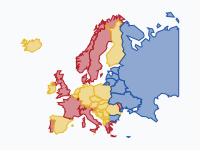
Wijn, bier of wodka? Europa 1800–heden

3 views

Welke drank domineert per land, 1800 tot heden? Rood = wijn, geel = bier, blauw = sterkedrank (wodka, jenever, akvavit/brandewijn, rakija). Kleur = de drank met het grootste aandeel in de geconsumeerde pure alcohol. Methode: huidige landsgrenzen voor de leesbaarheid; Turkije en de Kaukasus zijn weggelaten, Rusland tot de Oeral. Overgangsjaren zijn afgerond op het dichtstbijzijnde keyframe. Bronnen: Holmes & Anderson / Univ. of Adelaide Wine Economics (aandelen wijn/bier/sterkedrank 1888–92, 1925–29, 1961–64, 1980–84, 2010–14); WHO Global Information System on Alcohol and Health (2016/2019); Nordic Welfare Centre / CAN (Zweden 1861–2023: brandewijn tot 1989, bier tot 2002, daarna wijn); PARPA (Polen: bier passeert wodka in 1999). Let op: vóór ±1890 en voor Oost-Europa en de Balkan vóór 1960 zijn er nauwelijks betrouwbare cijfers; die kleuren zijn onderbouwde schattingen. Regionale verschillen (Moezel- en Paltswijn, Noord-Franse bierstreek, Pruisische brandewijn) vallen weg in landsgemiddelden. In Rusland haalt bier sterkedrank volgens recente verkoopcijfers in, maar volgens de WHO-cijfers is sterkedrank nog koploper.

Latest from the Blog

View all →
Oct 22, 2026

Tapestry: History Maps Embroidered on Linen, After House of the Dragon

Tapestry is a new map style that turns an animated history map into embroidery on a linen cloth, inspired by the opening titles of House of the Dragon. Territories are raised thread, every change of hands is unpicked and stitched anew, and armies slide over the cloth as appliqué pieces.

Oct 22, 2026

The Wars of the Roses, 1455–1487: Every March, Landing and Battle on One Map

An animated map of the Wars of the Roses told through the moving armies: every march, landing, flight and battle between York, Lancaster and Tudor from 1455 to 1487, day by day where the chronicles allow it, on an embroidered linen map.

Oct 21, 2026

Brabant Through Time: From Caesar's Belgae to Five Provinces in Two Countries (57 BC – 2026)

An animated map that follows Brabant from the tribes Caesar met in 57 BC through the medieval duchy, Burgundian, Habsburg and Spanish rule, the split of 1648 and the French period, to today's five provinces in the Netherlands and Belgium.
Moving Polygons

Visualize how regions and territories change over time with animated polygon maps.

Navigation

  • Explore Maps
  • Create with AI
  • Dashboard
  • Blog
  • Pricing
  • Contact

Use Cases

  • Historical Maps
  • Economic Policy
  • Urban Planning
  • Business Intelligence
  • Climate & Environment
  • All Use Cases

Legal

  • Privacy Policy
  • Terms of Service
  • Cookie Policy

© 2026 Moving Polygons. All rights reserved.